
Sony Patents a System That Reroutes Cameras When a 3D Model Fails
Getting a clean 3D model of something in the real world is surprisingly fragile: one passerby, one parked truck, and the whole scan falls apart. Sony's new patent describes a system that watches for those problems in real time and tells the camera operator exactly how to fix them.
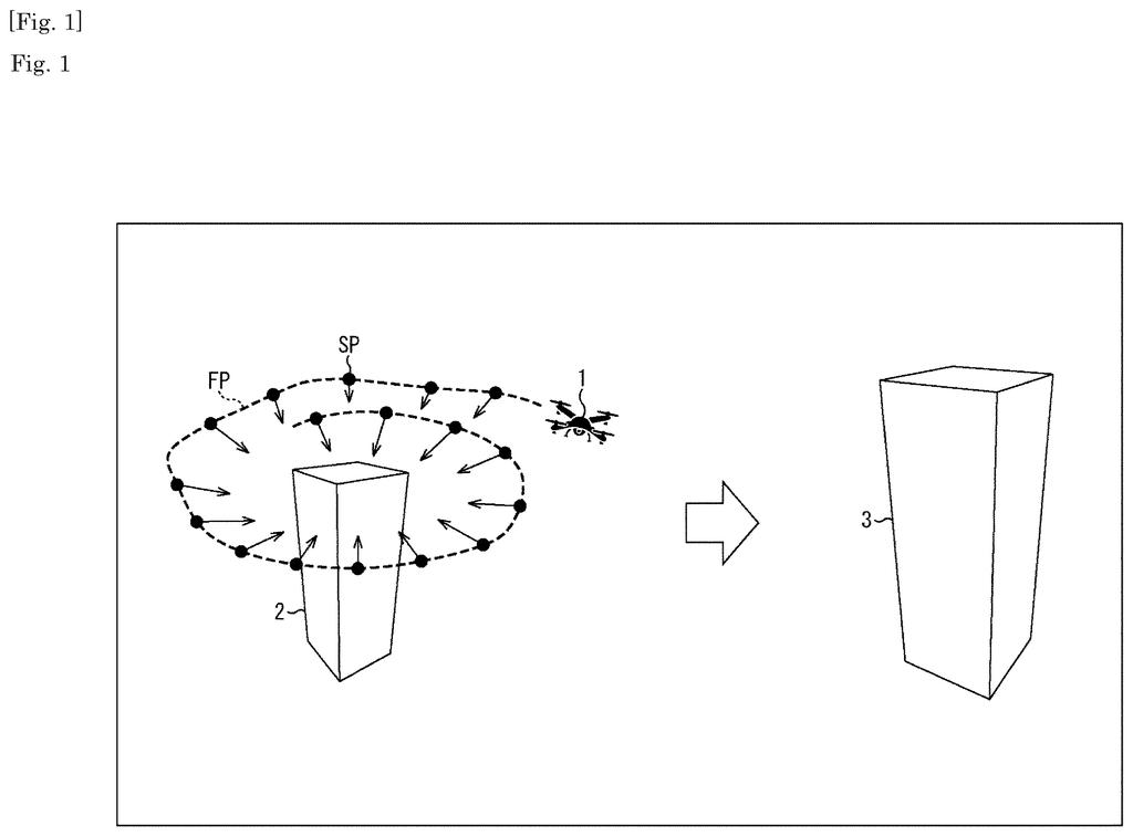
What Sony's obstacle-avoiding 3D scan guide actually does
Imagine you're trying to build a precise 3D model of a building or a crime scene using a camera mounted on a drone or a car. Everything looks fine on the screen, but when the software tries to stitch the images together, a truck that drove through the frame, or a tree branch that swayed in the wind, corrupts the result. You don't find out until it's too late to reshoot.
Sony's patent describes a system that catches those problems while the shoot is still happening. Sensors on the moving vehicle feed data into the system continuously, and it flags anything in the frame that could hurt the final 3D model. When it spots something troublesome, it spits out a revised shooting plan so the operator or the drone's autopilot can adjust the route on the fly.
The goal is fewer ruined scans and fewer expensive return trips. Instead of discovering the problem back at the office, you get a warning and a fix in the field.
performing, based on sensing information acquired in a moving body, processing of detecting a defective subject that may degrade a performance of three-dimensional modeling of a subject of interest using images shot from a plurality of viewpoints …
Translation: The system looks for obstacles that ruin 3D scans using camera feeds from a moving vehicle.
How the system detects bad frames and replans the shot
The patent centers on what Sony calls a "defective subject" detector. A defective subject is anything in the camera's frame that could degrade the quality of the 3D model being built from those images: a moving vehicle, a pedestrian, temporary scaffolding, or even uneven lighting conditions.
The system pulls in sensing information from a moving platform (a drone, a car, a robot) and runs continuous analysis to check whether anything in the current or predicted field of view falls into that defective category. The sensing data could include camera feeds, depth sensors, or GPS positioning.
When a defective subject is detected, the system outputs video shooting plan information. That is basically a revised instruction set for how the camera should move or where the vehicle should go next, designed to minimize how much of the bad element ends up in the captured frames. Think of it as a GPS reroute, but for camera angles instead of roads.
The practical pipeline looks something like this:
- Sensors on the vehicle stream data into the processing system
- The system identifies elements that would corrupt multi-angle 3D reconstruction
- A revised shooting plan is generated and output in real time
- The operator or autonomous platform adjusts accordingly
What this means for 3D mapping and on-site scanning
3D scanning from moving vehicles is already used in construction surveys, autonomous vehicle mapping, film production, and forensic documentation. The weak link in all of those workflows is the same: you often can't tell a scan is ruined until you're back at a desk reviewing it. A return visit to a construction site or a closed crime scene is expensive or sometimes impossible.
A system that catches problems in real time and issues corrective guidance could make mobile 3D scanning far more reliable without requiring more powerful hardware. For you as an end user, that eventually shows up as more accurate maps in navigation apps, better digital twins of buildings, and fewer artifacts in the 3D environments that AR and VR experiences depend on.
Sony's 67th filing in camera patents we've tracked since May adds to earlier work like one on filtering light by material and one filling in missing color data.
Spending computing power mid-scan to avoid a bad scan later is a sound trade, but it assumes the detection system is right. When it flags something harmless as a problem and reroutes the camera, the resulting scan can end up with worse coverage than if the system had done nothing at all. False alarms are not neutral here; they actively change where the camera goes, and a bad detour can leave gaps just as damaging as the obstacle it was trying to avoid.
That cost is real, but it is also the cost of any automated quality check. The alternative is a person catching the problem manually, or missing it entirely and discovering the failed scan only after the equipment has packed up and left.
For drone surveys or construction mapping, where a rescan means sending a crew back out, this feedback loop earns its keep. The trade reads as worth taking, provided the detection is tuned conservatively enough that it stays quiet when it is uncertain.
There are more where this came from
We read every patent application Big Tech publishes and send you the ones worth knowing. Plain English, free, every week.
The drawings
26 drawing sheets from US 2026/0278921 A1 · click any drawing to enlarge


Want this weekly breakdown for a company we don't cover? Patentlyze Pro →