
Google Patents Using Shared Tourist Photos to Pick Landmarks for Walking Directions
Your phone often starts directions with 'go north,' which is useless if you have no idea where north is. Google's patent mines tourist photos to find landmarks like a fountain or a bank that you can point to instead.
What Google's landmark-photo patent does
Today, when you ask your phone for walking directions, the first line is often something like 'go north on State Street.' That's little help when you're standing still and have no idea which way north is, and your phone can't reliably tell which way you're facing while you're at rest.
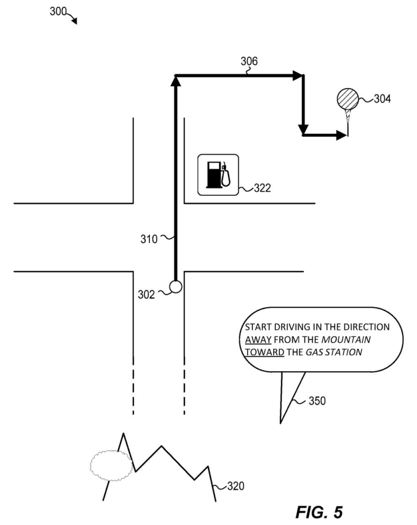
Google's filing swaps that for landmarks: 'walk away from the fountain and toward the bank.' To know what you can actually see from a given corner, the patent leans on photos people have already shared. If lots of people tag pictures of the same building, and those pictures were taken from the same intersection, that intersection becomes a spot where the building is clearly visible.
The filing's own example: out of 1,000 photos of the National Gallery of Art, 40% might come from one intersection and 30% from another. The system would log both spots, plus which direction the building lies from each.
… determining, by the one or more processors, a location from which each of the set of photographs were captured; determining, by the one or more processors, a direction from the determined location to the landmark; …
Translation: The system figures out exactly where tourists stood to take each photo and which way they pointed their cameras.
How shared photos become landmark directions
The independent claims cover the behind-the-scenes database step. Claim 1 describes a method that identifies a set of photographs of a landmark, works out the location each was captured from, determines the direction from that location to the landmark, and updates a database to link all three.
The dependent claims add specifics:
- The photos are ones shared by users and tagged with the landmark's title.
- The system clusters (groups together) the photo locations to find an intersection where many were taken, then repeats for a second intersection.
- The direction from the intersection to the landmark comes from map data.
- A landmark can get a score for observability (how reliably you can spot it from where you stand) or prominence, based on how many photos came from that spot.
The description explains where this feeds in. When a route starts, the system considers everything perceptible within a 360-degree range of your location. It picks landmarks using observability, prominence and uniqueness, plus your preferences, such as liking billboards. It can reference things behind you or far away, like a mountain, and even sounds ('walk toward the music'). Claim 2 and its matching claims tie the database to that first instruction.
… candidate navigation landmarks perceptible within a 360-degree range of the current location of the portable device are identified using (i) one or more metrics of observability, prominence, and uniqueness and (ii) a user preference related to a type of landmark …
Translation: Nearby objects are picked based on how visible and unique they are, plus what kind of sights the user likes.
Why directions that name landmarks help you
If this reaches an app you use, your first step could come with a clear cue: walk toward the bank, away from the fountain. That helps most when you step out of a subway station or parking garage in an unfamiliar city and can't tell which direction you're facing.
It also shows how much can be learned from photos strangers already shared. Tagged pictures and their locations become a record of what can be seen from which corner, a way to cover many corners at once. The filing also mentions street-level imagery and 3D models as other sources, and in one example it says the objective scores outrank your personal landmark preferences.
Google's 1035th filing we've tracked since May in our Google coverage continues Wing's drone push, joining applications for wind-resistant pickup stands and self-mapping charging pads.
Claim 1 never mentions directions, phones or walking. It covers collecting photos of a landmark, finding where they were taken, working out which way the landmark lies from there, and saving that in a database. That is a wide net: any landmark, any set of photos, any database.
The navigation part shows up in claim 2 and its matching claims, which add the route and the first spoken instruction. On paper, claim 1's wording would apply to any service that builds a 'visible from here' list this way, even one with no turn-by-turn feature.
The idea is sensible and easy to picture, and the photo-counting step carries the real substance. Claim 7 scores landmarks by how many photos came from a spot, so well-photographed places naturally rank highest.
Get our take in your Top Stories
Liked this breakdown? Add Patentlyze as a preferred source on Google, and our plain-English take shows up more often in your Top Stories the next time Google patent news breaks.
There are more where this came from
We read every patent application Big Tech publishes and send you the ones worth knowing. Plain English, free, every week.
The drawings
7 drawing sheets from US 2026/0348738 A1 · click any drawing to enlarge


Want this weekly breakdown for a company we don't cover? Patentlyze Pro →
Be the first to weigh in