
Zoox Patents a System That Draws Its Own Road Maps While Driving
Most self-driving cars depend on detailed pre-built maps that can go stale within hours. Zoox is patenting a system that skips the wait and lets the car draw its own map in real time, using nothing but its onboard sensors and a machine-learning model.
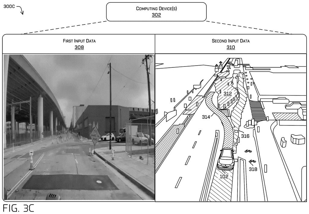
How Zoox's car builds its own map on the fly
Self-driving cars today rely heavily on maps that engineers built in advance, sometimes weeks or months before the car actually drives that road. The moment a construction crew puts up a barrier or a new lane marking appears, the map is already out of date.
Zoox wants its vehicles to build their own maps on the spot. The car's cameras and other sensors take in the scene from multiple angles at once, and an AI model stitches that information together into a live picture of the road: where the lanes are, which direction they run, where the drivable surface ends, and whether there's a construction zone or a blocked-off area up ahead.
That freshly drawn map then feeds directly into the part of the system that decides where the car should go next. Instead of checking a pre-loaded file, the vehicle is essentially reading the road for itself, moment to moment.
… generating, by the machine learned model and based at least in part on the first sensor data, the image data, and the historical data, a map comprising features including a drivable surface or a non-drivable surface; and controlling the autonomous vehicle in the environment based at least in part on the map.
Translation: The AI uses camera data and past records to instantly map out the road ahead and steer the vehicle.
How the AI fuses sensor views and history into a live map
The system pulls data from at least two sensors on the vehicle simultaneously, for example a forward-facing camera and a side camera, producing different views of the same environment. Those raw sensor feeds are converted into a consistent image format so the AI model can compare them side by side.
Alongside the live sensor data, the model also receives historical data: information about objects that were detected a moment ago (like a pedestrian's last known position), regions flagged in a previous pass (like an occluded area where the sensors couldn't see), or chunks of a stored map for the area nearby. Feeding in this context stops the model from starting from scratch every fraction of a second.
The machine-learned model (a neural network trained to interpret road scenes) combines all of that input and outputs a structured map. That map includes:
- Lane positions and the connections between them
- Road topology (how roads branch, merge, or end)
- Traffic signs and signals
- The boundary between drivable and non-drivable surfaces
- Special regions such as construction zones or spots the sensors can't fully see
The map is then handed to the vehicle's planning component, which uses it to predict a safe trajectory and issue driving commands, all within a timeframe short enough to respond to changing conditions.
A machine learned model can receive the view data and historical data (e.g., a state of a detected object) as input data and generate a map of features proximate the vehicle that include lane information, connections between lanes, road topology, traffic signs, a drivable surface boundary, and/or region information (e.g., a construction zone, occluded region, etc.).
Translation: The software combines live sensor views and past data to instantly map lanes, signs, and construction zones.
What live map-making means for self-driving reliability
Pre-built maps are one of the quieter vulnerabilities in modern self-driving systems. They require expensive, repeated survey drives to stay current, and they can fail badly in exactly the situations that matter most: fresh road work, unexpected closures, or any place the mapping crew never covered. A vehicle that can generate its own map in real time doesn't eliminate all of those risks, but it dramatically shrinks the window during which the car is operating on stale information.
For Zoox specifically, which operates a purpose-built robotaxi in a fixed service area, the ability to handle dynamic, unplanned changes without waiting for a map update could be the difference between a reliable product and one that has to pull over whenever a cone moves. Autonomous vehicle map technology is one of the more active areas of Big Tech patent news, and Zoox's approach of baking map generation directly into the vehicle's AI loop rather than treating it as a separate offline step is a meaningful architectural choice.
This is the 21st Amazon filing we've tracked in our self-driving sensing race since May, building on a branching collision search and a risk-before-every-move application for self-driving cars.
The gap between this patent and a real product is mostly software. The vehicle already has the cameras and sensors it needs; what this describes is a way to let the car's decision-making system use a freshly built map of its surroundings rather than one downloaded in advance.
The remaining obstacle is trust. A map drawn on the fly by a neural network has to be right nearly every time before you put passengers in the car, and proving that requires testing across thousands of unusual situations the system has never encountered.
The specificity of the technical claims here suggests an engineering team working from something real, not a whiteboard idea. That makes this a meaningful step toward a car that can handle roads and conditions that no one mapped ahead of time.
Get our take in your Top Stories
Liked this breakdown? Add Patentlyze as a preferred source on Google, and our plain-English take shows up more often in your Top Stories the next time Amazon patent news breaks.
There are more where this came from
We read every patent application Big Tech publishes and send you the ones worth knowing. Plain English, free, every week.
The drawings
6 drawing sheets from US 2026/0249887 A1 · click any drawing to enlarge


Want this weekly breakdown for a company we don't cover? Patentlyze Pro →
Be the first to weigh in