
Nvidia Patents a Way for Self-Driving Cars to See Around Their Own Blind Spots
A self-driving car that can't see around a parked truck is a self-driving car that might drive into one. Nvidia's latest patent describes a method for vehicles to draw a map of exactly what they can't see, so they can plan around it.
How Nvidia's blind-spot mapping works in plain English
Ever driven up to a busy intersection and realized a delivery van is blocking your view of oncoming traffic? You slow down, inch forward, and try to figure out what's hiding in the gap. A self-driving car faces that problem constantly, and it has to solve it in milliseconds.
Nvidia's patent describes a system that builds a live map of an environment and then figures out which parts of that map the vehicle's sensors simply cannot see. Think of it like drawing a spotlight: everything inside the lit area is known, and everything in the shadows is flagged as a potential risk. The car can then treat those shadowed zones with extra caution when deciding how to steer, brake, or merge.
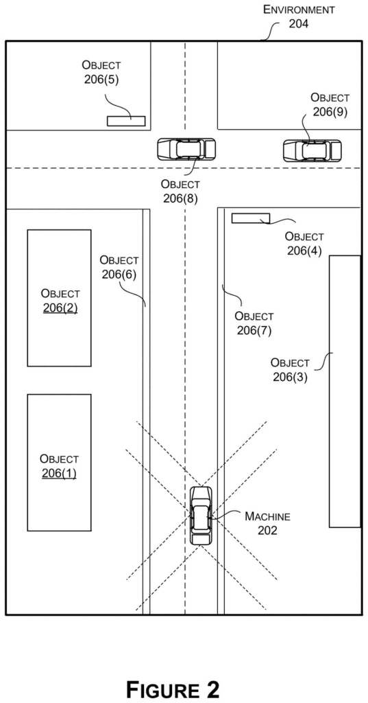
The system combines camera images with radar data to get a three-dimensional picture of nearby objects, then flattens that picture into a top-down grid. From there, a technique borrowed from video-game graphics, called ray tracing, shoots invisible beams outward from the vehicle and marks where each beam hits something solid, outlining the hidden zones beyond.
generating, based at least on a three-dimensional (3D) occupancy map associated with an environment, a two-dimensional (2D) occupancy map associated with the environment; …
Translation: The software simplifies a 3D environmental map down into a flat 2D version to process faster.
How radar, cameras, and ray tracing build the occlusion map
The patent lays out a pipeline with several connected steps.
First, the vehicle's sensors, cameras fused with radar, build a 3D occupancy map (a three-dimensional grid where each cell is marked "something is here" or "nothing is here"). That 3D map is then collapsed into a flat, top-down 2D occupancy grid, like squashing a layered cake into a single photo viewed from above.
Next, the system runs ray tracing, a technique that shoots beams outward in many directions from the vehicle's position. When a ray hits a marked cell (an occupied spot, say a wall or a parked car), it stops. The points where all those rays stop are then connected to form a polygon, a boundary shape that outlines everything the vehicle CAN see.
Anything outside that polygon is, by definition, hidden from the sensors. That hidden region becomes an occlusion map: a spatial record of exactly where the car is blind.
- Fused camera and radar data feed into a 3D grid
- The 3D grid is flattened into a 2D top-down map
- Ray tracing finds the edge of visible space
- A polygon marks the boundary; everything beyond is flagged occluded
- The occlusion map feeds into planning, control, and navigation decisions
The final output is actionable: the vehicle's planning system uses the occlusion map to decide how to move, when to slow down near uncertain zones, and how to route around areas where hidden hazards might appear.
… use ray tracing with regard to the 2D occupancy map to identify one or more occluded areas of the environment.
Translation: It shoots virtual rays across the map to figure out what the vehicle cannot see.
What smarter blind-spot detection means for autonomous vehicles
Blind spots are one of the hardest unsolved problems in autonomous driving. Sensors are excellent at detecting what they can see, but a pedestrian crouched behind a parked van, or a cyclist approaching from a hidden driveway, is invisible until it's nearly too late. A system that explicitly maps where it cannot see lets a vehicle treat uncertainty as a first-class part of its planning, not an afterthought.
For you as a passenger or a nearby pedestrian, this translates to a car that knows when to be extra cautious rather than assuming the coast is clear. several Nvidia filings on autonomous vehicle perception this year suggest the company is treating sensor fusion and environmental mapping as a core part of its self-driving stack, not just a supporting feature.
Nvidia's 61st filing we've tracked since May in our self-driving sensing race watchlist adds to a run that includes one on spotting open car doors and one fusing radar and camera feeds.
Claim 1 requires four steps to all happen together: flatten a three-dimensional picture of the surroundings into a flat grid, use light-ray math to find hidden zones, draw a shape around what the vehicle cannot see, and feed that shape into the system deciding the vehicle's next move. All four must be present at once, which makes the claim narrower than the abstract suggests.
That narrowness still has real reach. The sequence Claim 1 describes is close to how any self-driving vehicle reasons about blind spots, so a granted patent here would cover any car, drone, or robot that follows these steps in order, regardless of whose hardware is underneath.
Nvidia sells the chips and software that run exactly this kind of processing, so protecting the method rather than a single product means the coverage travels with whoever deploys the pipeline. That is where the commercial weight sits.
There are more where this came from
We read every patent application Big Tech publishes and send you the ones worth knowing. Plain English, free, every week.
The drawings
27 drawing sheets from US 2026/0278990 A1 · click any drawing to enlarge


Want this weekly breakdown for a company we don't cover? Patentlyze Pro →