
Samsung Patents an AI System That Matches Robot Scans to Building Floor Plans
Getting a robot to know exactly where it is inside a building sounds simple, but matching the map a robot draws on its own to an architect's floor plan is a surprisingly hard problem. Samsung has filed a patent for an AI-assisted system that does exactly that, automatically.
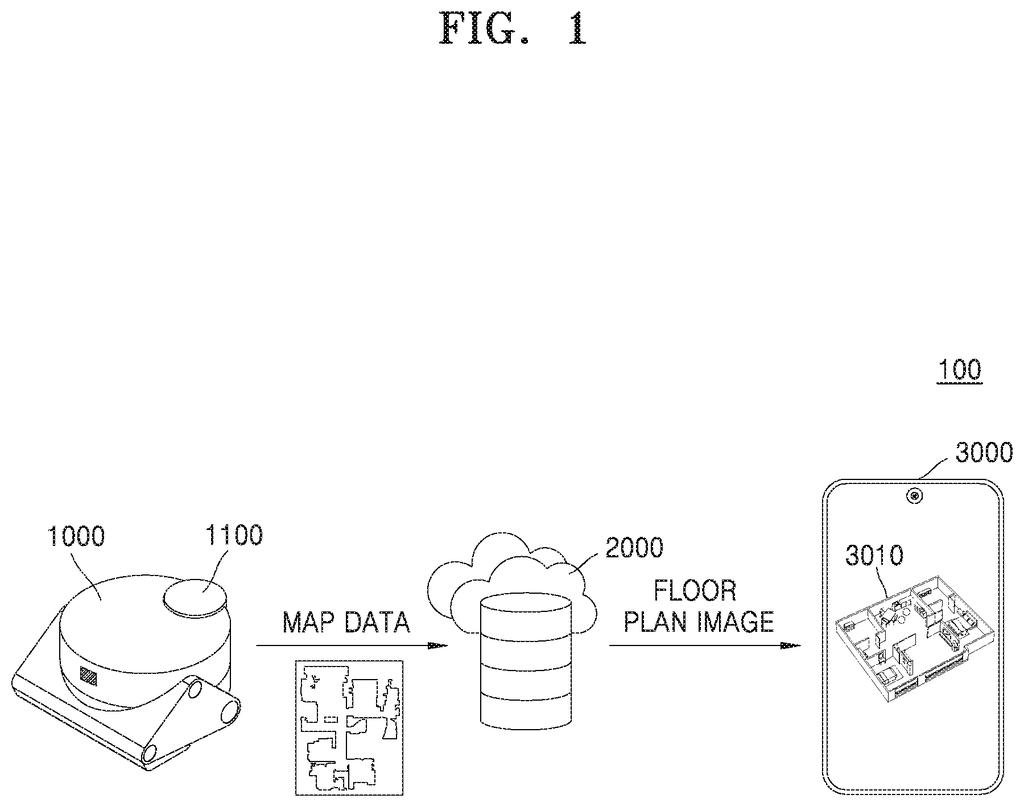
How Samsung lines up robot maps with real floor plans
A delivery robot rolls through a shopping mall. It builds its own rough map of the space as it goes, but that internal map and the mall's official floor plan rarely line up perfectly on their own. Someone, or something, has to reconcile the two.
Samsung's patent describes a server-side system that takes care of this automatically. It starts by reading a building's floor plan image and using an AI model to divide the space into distinct areas, like corridors, rooms, and open halls. It then removes certain areas from consideration, specifically the zones the robot's laser sensor never physically visited. That trimmed-down comparison makes it much easier to accurately line up the robot's self-built map with the official floor plan.
The practical payoff is that indoor robots could more reliably know their precise position inside a building, without a human having to manually correct their maps every time they're deployed somewhere new.
… segmenting the indoor space into a plurality of areas by inputting the first floor plan image into a first artificial intelligence model; …
Translation: An AI breaks the building layout down into distinct zones.
How the AI strips out problem areas before aligning maps
The system works in several coordinated steps, handled by a server rather than the robot itself.
- Floor plan segmentation: The server takes an image of the building's official floor plan and feeds it into an AI model. The model divides the floor plan into labeled regions, separating walkable corridors from rooms, stairwells, and other distinct zones.
- Selective trimming: The server identifies a "predefined area" to exclude, meaning zones the robot didn't actually visit. This produces a trimmed version of the floor plan that only covers the territory the robot explored.
- LiDAR map extraction: The robot carries a LiDAR sensor (a laser-based scanner that measures distances to build a 3D point cloud of its surroundings). The server receives the full scan data plus a record of the robot's path, called trajectory information. Using that path record, the server pulls out only the portion of the scan matching where the robot actually traveled.
- Alignment: With both datasets trimmed to the same territory, the server aligns the robot's self-built map with the official floor plan. Comparing two smaller, matching regions is far more accurate than trying to overlay two mismatched full-building datasets.
The key insight is that reducing both inputs to the same geographic subset before alignment dramatically cuts down on ambiguity and error.
What this means for indoor robots and warehouse automation
For indoor robots, precise localization (knowing exactly where they are on a map) is the difference between reliably completing a task and bumping into a wall. Today, deploying a robot in a new building often requires manual map calibration. A system that handles this automatically could make robots far cheaper and faster to set up in warehouses, hospitals, hotels, and retail spaces.
Samsung's steady investment in indoor-robot navigation points toward autonomous devices, like robotic vacuum cleaners and delivery units, that need to work in complex, real-world indoor environments. Better map alignment is foundational infrastructure for all of those products.
That makes this Samsung's 41st filing we've tracked since May in our home robot patents, a series that already covers magnetic charging connections and dead-end navigation fixes.
Claim 1 is fairly specific in its steps: segment a floor plan with an AI model, exclude an unvisited predefined area, extract the robot's actual traveled path from its LiDAR data, then align using those two trimmed datasets together. That sequence is narrow enough to leave room for competitors who exclude areas differently or skip the trajectory-based trimming step entirely.
That said, the claim does cover the core idea of using the robot's actual travel history to shrink the comparison problem before alignment happens. Anyone building a server-based map alignment system for LiDAR robots would naturally want to do something similar, which gives this patent at least some practical teeth.
The filing reads like applied engineering work rather than a conceptual leap, filling in a real operational gap in indoor robot deployment. Whether it survives a prior-art challenge depends on whether this specific combination of steps has appeared in academic robotics literature before, and that literature is extensive.
There are more where this came from
We read every patent application Big Tech publishes and send you the ones worth knowing. Plain English, free, every week.
The drawings
29 drawing sheets from US 2026/0268507 A1 · click any drawing to enlarge


Want this weekly breakdown for a company we don't cover? Patentlyze Pro →