
Qualcomm Patents a Way to Build AR Maps Using Radio Signals
Augmented reality headsets struggle to know exactly where they are indoors, where GPS goes dark. Qualcomm is patenting a method that uses ordinary radio frequency signals floating through the air to build a map on the spot and snap it into the right place on a bigger, pre-loaded map.
How Qualcomm's radio-signal maps place you inside an AR space
Every time you walk into a large building wearing an AR headset, the device has to figure out where it is without any GPS signal to lean on. That sounds simple, but it's one of the hardest problems in mixed reality.
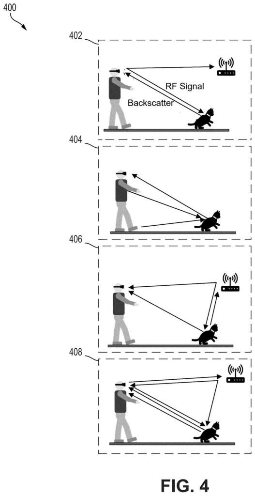
Qualcomm's new filing describes a system that reads the radio frequency (RF) signals already drifting through any building, like those from Wi-Fi routers or cellular base stations, and uses the pattern of those signals to sketch a rough map of the local area. The device then lines that sketch up against a reference map stored in advance. When the two match, the device knows exactly where you are, and it can overlay digital content in precisely the right spots.
The practical payoff: AR content, arrows, labels, virtual objects, would stay anchored to their correct physical locations even in spaces where GPS can't reach. Think warehouse picking, hospital navigation, or shopping malls.
generate, based on a received radio frequency (RF) signal, a local map representing an area in which a first device is located …
Translation: The system builds a map of the surrounding area using only wireless signals.
How RF signals become a positioned local map for XR
The patent describes a pipeline with four main stages running on a computing device (a headset or a phone paired with AR glasses):
- Map generation from RF signals: The device picks up radio frequency signals, think Wi-Fi or cellular fingerprints, and uses their strength and timing patterns to build a local map representing the physical geometry of the space around it. RF signals bounce off walls and objects, so their signal shape carries spatial information.
- Feature alignment: The system compares identifiable features of that freshly built local map against a reference map, a pre-surveyed floor plan or point cloud associated with a known location. This is similar to how image-stitching software lines up overlapping photos by matching corner points.
- Location determination: When the feature sets align well enough, the device concludes it is at that predetermined location. No GPS needed.
- XR rendering: The device then renders a virtual overlay that combines the local map and the reference map, letting virtual objects sit at their correct real-world coordinates.
The claim is hardware-agnostic: it covers any processor-and-memory apparatus, which means the technique could run on a standalone headset, a phone, or a cloudlet nearby.
… align features of the local map with features of a reference map associated with a predetermined location …
Translation: It figures out where you are by matching your local map to a master map.
What this means for indoor AR navigation and XR headsets
Indoor positioning has been a weak link in AR for years. Camera-only approaches (called visual SLAM) fail in low-light or featureless corridors. Dedicated UWB or LiDAR sensors add cost and bulk. Using RF signals that are already present in most buildings sidesteps both problems, at least in theory.
If this works at commercial scale, it could make AR-assisted navigation practical in the kinds of spaces, hospitals, airports, big-box stores, factories, where people actually get lost. For Qualcomm, whose chips already process Wi-Fi and cellular signals in most of the world's headsets and phones, Qualcomm keeps filing on indoor XR positioning, this approach plays directly to existing silicon they already sell.
Qualcomm's 41st filing we've tracked since July in the AR glasses race adds to a run that includes one on moving AR labels and a cover-glass laser safety check.
RF signals are everywhere, but they're also unstable. A rebooted router, a moved shelf, or a crowded room on a busy day can all scramble the signal patterns this system relies on to figure out where you are.
Qualcomm's design leans on a matching step, comparing a freshly captured signal map against a carefully pre-surveyed reference map, hoping the two share enough in common despite the noise. That's a reasonable approach in a stable, controlled space like a warehouse, but it transfers the hard work from sensor hardware to whoever has to keep that reference map accurate over months and years.
The trade is plausible rather than painless. You spend less on fancy sensors and more on ongoing map maintenance. Whether that's a good deal depends entirely on whether the people deploying this can commit to that upkeep, and most can't.
There are more where this came from
We read every patent application Big Tech publishes and send you the ones worth knowing. Plain English, free, every week.
The drawings
8 drawing sheets from US 2026/0278948 A1 · click any drawing to enlarge


Want this weekly breakdown for a company we don't cover? Patentlyze Pro →