
Qualcomm Files Patent for Roadside Equipment That Catches Bad GPS Satellite Data
Qualcomm's patent turns streetside equipment into a lie detector for GPS satellites, checking whether a satellite really is where it says it is.
What Qualcomm's roadside satellite check does
You're driving through a city center, and your car's map dot suddenly slides a block off the road. Tall buildings can cause that, but so can a GPS satellite broadcasting slightly wrong information about its own position.
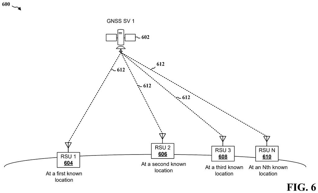
Qualcomm's patent describes a fix built on roadside units: small communications boxes placed along streets, each with a known location. Every unit listens to the same satellite and measures how far away it seems to be. A central computer combines readings from at least four units, works out where the satellite really is, and compares that with where the satellite claims to be.
If the two don't match, your device can be told to ignore that satellite or trust it less, so one bad signal doesn't throw off your position.
perform at least one of: a measurement of a pseudo-range (PR) between the RSU and a satellite, an estimation of a position of the satellite based on ephemeris (EPH) data or almanac (ALM) data of the satellite, or an estimation of a clock offset associated with the satellite based on the EPH data or the ALM data of the satellite; …
Translation: The roadside unit measures its distance to a satellite and checks the satellite's math and clocks.
How roadside units catch a bad satellite
The claims cover the roadside unit's job. A roadside unit (RSU) is a radio box placed along a road that has its own GPS receiver and a known location. It does at least one of three things:
- Measures a pseudo-range, its estimated distance to a satellite based on how long the signal took to arrive ("pseudo" because small timing errors make the number imperfect).
- Estimates the satellite's position from ephemeris or almanac data, which are orbit details the satellite broadcasts about itself. Ephemeris is precise and valid for about two hours either side; almanac is rougher and can last up to 90 days.
- Estimates the satellite's clock offset, meaning how far its onboard clock has drifted.
The unit sends its results to a network entity, which can be a base station, a location server, or another roadside unit. In the description, that entity gathers readings from at least four units, favors ones spread far apart or in different directions, and uses them to work out where the satellite actually is. It then compares that against the broadcast orbit data to spot an error.
The roadside unit gets information back: an error flag, a scale factor (for example 1 to 10), a weight factor (for example a percentage), or a quality rating such as good, acceptable or bad. It can pass that on to nearby devices, which decide whether to drop the satellite or give it less weight.
Readings can be gathered on a schedule or on demand. The filing says on-demand requests cut power use and network chatter.
Aspects presented herein may enable a network entity to determine whether there are any errors in the broadcast data from one or more space vehicles (SVs) based on crowd-sourcing information from a set of road side units (RSUs).
Translation: The system uses roadside units to crowd-source and spot mistakes in satellite data.
Why a wrong satellite matters in city driving
Satellite navigation on a phone or car is typically accurate to about 5 to 15 meters, and the filing says today's ways of spotting a bad satellite have gaps. Integrity files that list satellite problems arrive in updates every 4, 6, 12 or 24 hours. Correction services can be hard to decode in dense city areas. And a receiver's own cross-checking can't help when a satellite is unusable but still broadcasting wrong data.
A check running in near real time from the roadside targets those gaps. The filing points to vehicle-to-everything applications, where cars exchange data with roadside equipment and self-driving features need position information without interruption. For you, the payoff would be a map position that holds steady in the moments when a satellite goes wrong.
Qualcomm's 46th filing we've tracked since July in the self-driving sensing race adds to a run that includes one spotting hidden cars and signs and one filtering bad GPS signals.
If this works as described, you would notice it by noticing nothing. Your map dot stays on the right street instead of jumping a block when one satellite sends bad data, and the voice in your car doesn't send you down the wrong turn.
The catch is who builds it. Roadside units have to be installed along streets, kept powered and connected, and someone has to run the server that checks the satellites. Your phone gains nothing until that network exists near you.
For city drivers and for self-driving features that need exact position, the idea is sensible and easy to picture. For everyone else it stays invisible infrastructure, a useful piece of plumbing that pays off only on the day a satellite misbehaves.
Get our take in your Top Stories
Liked this breakdown? Add Patentlyze as a preferred source on Google, and our plain-English take shows up more often in your Top Stories the next time Qualcomm patent news breaks.
There are more where this came from
We read every patent application Big Tech publishes and send you the ones worth knowing. Plain English, free, every week.
The drawings
12 drawing sheets from US 2026/0309871 A1 · click any drawing to enlarge


Show the other 4 sheets


Want this weekly breakdown for a company we don't cover? Patentlyze Pro →
Be the first to weigh in