
Microsoft Patents an AI That Answers Questions About Whatever Your Phone's Camera Sees
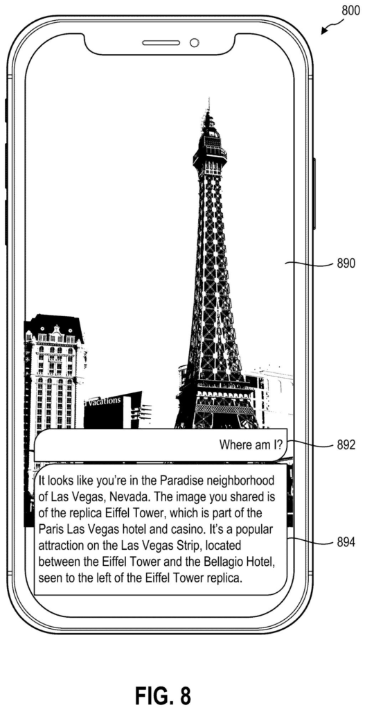
Point your phone's camera at a storefront, a street corner, or a building under construction, type a question about it, and get a specific answer. That's the core promise of a new Microsoft patent that combines live images with GPS coordinates and a library of past photos to give an AI real context about a place.
What Microsoft's location-aware AI assistant actually does
Every time you stop on a sidewalk and wonder what that new restaurant is, or what a building used to be before the renovation, you probably pull out your phone and start searching. The results are generic at best. Microsoft's new patent describes a system designed to do something more precise.
Instead of searching the web by keywords, the system takes three things at once: the live image from your camera, your GPS coordinates, and whatever question you typed. It then pulls up a stored profile of that location, built from previous photos taken there, and feeds all of it to an AI that uses the combined picture to craft an answer specific to where you actually are and what you're actually looking at.
The key idea is that your live photo gets compared against a historical visual record of the same spot. So the AI isn't guessing from location data alone or image recognition alone. It's cross-referencing both, which should make the answers more accurate and more grounded in real details about that specific place.
receiving a real-time image, real-time location data, and a user query from a client device …
Translation: The phone sends a picture, GPS coordinates, and a spoken or typed question.
How the system fuses GPS, live images, and stored visual history
The system works by creating what the patent calls a multimodal embedding (a mathematical fingerprint that combines information from different types of data, in this case images and GPS coordinates) for a given location. That embedding is stored in a vector embedding space, essentially a large database organized so that similar locations cluster together.
When a user submits a query from a phone, the system captures three inputs:
- A real-time photo from the device camera
- Real-time GPS or location data
- A natural-language question typed or spoken by the user
The system finds the embedding for that location. Crucially, the embedding already encodes visual features from previous images of the same place, not just coordinates. The live image's visual features are then compared against those stored features so the AI understands what has changed, what looks familiar, and what the place typically looks like.
All four inputs (live image, location data, user question, and the embedding) go to a generative AI model (an AI that produces written answers, similar to a large language model) with instructions to answer the question using the embedding as context. The model's response is sent back to the user's device.
… generates location-based responses for user queries by utilizing identified multimodal embedding and by instructing a generative AI model to respond …
Translation: An AI uses visual and location data to answer questions about the user's surroundings.
What this means for AR and on-the-go AI assistants
For everyday users, this closes a real gap in current AI assistants. Asking a voice assistant or chatbot about a specific physical location usually gets you generic information pulled from a web search. A system that combines live camera input with a stored visual history of a place can, in theory, tell you things like whether a construction project matches its approved plans, what a business used to look like, or what changed at a corner since the last street-level photos were taken.
a growing pile of Microsoft AI-assistant filings suggests the company is building toward camera-first, context-aware queries as a distinct product layer. The practical applications range from tourism and navigation to accessibility tools for people who rely on their phone to interpret physical surroundings.
Microsoft's 39th filing we've tracked under Enterprise AI since May adds to a run that includes one on merging news into one story and one on shielding data during AI runs.
Claim 1 covers any system that takes a live photo, a location, and a user question, then builds a combined representation by comparing that photo against stored historical images of the same place, and feeds everything to an AI to produce an answer. That scope is wide. A retail worker scanning a shelf, a home inspector photographing a foundation, and a blind user pointing a phone at a street corner all fall inside it.
The technical step doing the most work is the comparison between the live image and stored historical visuals of that location. That is what makes this more than a chatbot with a camera, and it is the step that would give this patent real blocking power over anyone building a place-aware AI tool.
If granted, this claim matters to any company shipping a product where a camera, a map, and an AI-generated answer work together. That category is growing fast, and this patent would sit at its center.
There are more where this came from
We read every patent application Big Tech publishes and send you the ones worth knowing. Plain English, free, every week.
The drawings
10 drawing sheets from US 2026/0300300 A1 · click any drawing to enlarge


Want this weekly breakdown for a company we don't cover? Patentlyze Pro →
Be the first to weigh in