
Amazon's Zoox Files Patent for Deciding Which Streets Its Robotaxis Can Handle
Before a robotaxi company adds a new neighborhood, it has to guess whether its cars can cope with the school zones, steep hills and busy crossings there. This Zoox filing swaps the guess for a score on every stretch of road.
What Zoox's street-scoring patent actually does
Imagine you run a robotaxi service that works well downtown, and you want to add the neighborhood next door. Some of its streets look just like ones your cars already handle. Others have a steep hill, a school zone, or a crowded crossing. How do you know which ones are safe to add?
That's the question this Zoox patent application tackles. It chops a city map into short road segments, lists what's on each one (fire hydrants, traffic lights, schools, hills), and groups segments that look alike. Then it gives each group a score for how well the car is likely to drive there.
If a group scores too low, the system estimates what it would cost to fix the car's software or hardware so the score improves. Streets that score well, or are cheap enough to fix, make it into the new service area.
… determining, based at least in part on the difference, to include the first discretized region within an operating area of the autonomous vehicle …
Translation: Deciding whether to let the robotaxi drive on a specific street by comparing its difficulty score to nearby areas.
How Zoox groups streets and grades each one
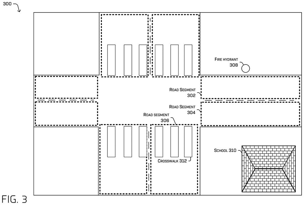
The system starts with map data pulled from a database and splits it into discretized regions (small, fixed pieces of the map). In the main example, each piece is a road segment: one or more lanes of equal length going the same direction.
For each region it collects attributes, such as school zones, fire hydrants, stop lights, parking spaces, emergency locations and steep slopes. These can come from labels already in the map, from a machine-learned model (software trained on examples to spot features), or from outside sources like city maps. Similar segments can be grouped into clusters by turning each into an embedding (a compact list of numbers describing it) and checking how close the lists are.
Next comes the score, which the filing calls a metric. The system finds logged drives with similar features, replays them in simulation, and counts things like:
- Disengagements (moments when a human or remote helper would need to step in)
- Stuck events and simulated collisions
- Rule violations and progress problems
- Comfort issues, such as hard braking or jerky steering
Claim 1 compares the scores of two regions. A small difference means the new region resembles one the car already handles, so it can join the operating area. The description also covers cost: for low scorers, engineers estimate the time needed to fix the problem, and more time means higher cost. The final operating area is sent to the vehicles, which are controlled based on it.
What this means for where robotaxis can go next
If you ride in or live near an autonomous fleet, this kind of system helps decide which streets get service and when. The filing says the aim is fewer stuck cars, smoother rides and fewer calls for remote help, because vehicles only drive where they have shown they can cope.
For the company, it turns expansion into a ranked to-do list: add the easy streets now, and price out the hard ones before committing engineers. The application is early in review, and the examiner's first pass rejected the claims as filed, which is routine and usually followed by amendments. Nothing here is approved, and the filing names no city or launch date.
Amazon's 34th filing we've tracked since May in our self-driving sensing race watchlist follows earlier Zoox applications on guessing which path first and listening for police orders.
The big trade here is detail for speed. Grouping streets by their listed features lets a company judge thousands of road segments without testing each one in person. The cost is that a street with a quirk nobody labeled on the map, like a blind driveway, gets scored as if it were its neighbors.
The second trade is that the score comes from simulation and past driving logs. That is cheap and fast, but it only knows the situations the logs captured, so a street can look easy on paper and still surprise a real car.
Folding in the cost of fixes is the smartest part, because it lets a company ask whether a hard street is worth the engineering time. The risk is that dollars and hours start to shape what counts as safe enough. The trade reads as worth it, as long as safety sets the thresholds and cost only breaks ties.
Get our take in your Top Stories
Liked this breakdown? Add Patentlyze as a preferred source on Google, and our plain-English take shows up more often in your Top Stories the next time Amazon patent news breaks.
There are more where this came from
We read every patent application Big Tech publishes and send you the ones worth knowing. Plain English, free, every week.
The drawings
6 drawing sheets from US 2026/0348734 A1 · click any drawing to enlarge


Want this weekly breakdown for a company we don't cover? Patentlyze Pro →
Be the first to weigh in