Sony Patents a Drone Control System That Puts You Inside the View
Sony is patenting a way to let you pilot a drone from a viewpoint you place yourself, not from where you're standing, but from a virtual camera position you define in the scene.
What Sony's virtual-viewpoint drone control actually does
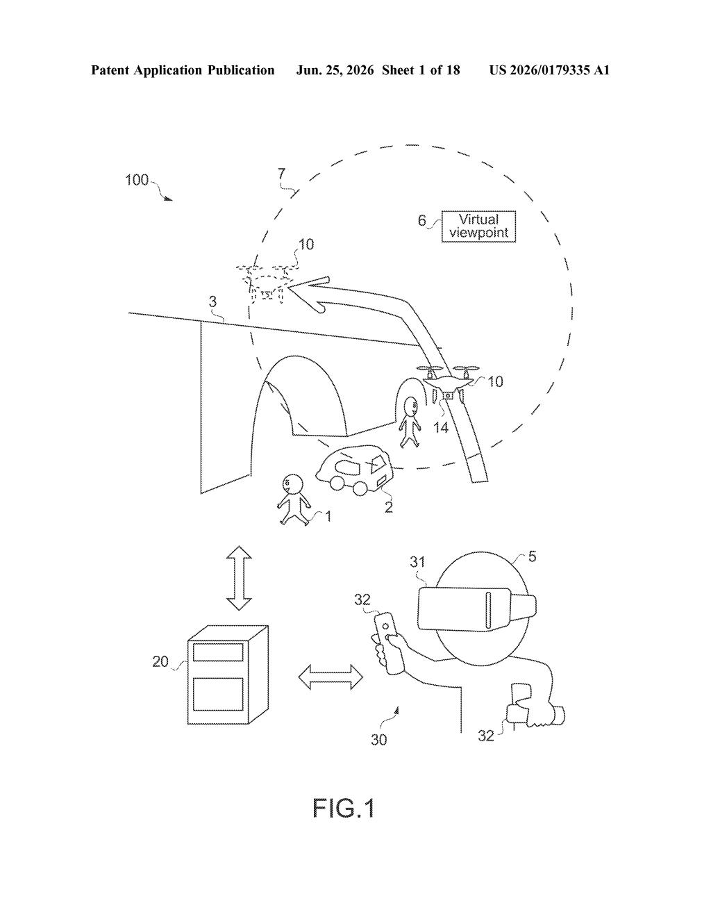
Imagine you're flying a drone around a building. Right now, most drone controllers tie your perspective to where you are standing or to the drone's own camera. Sony's patent describes something different: you pick a virtual viewpoint somewhere in the scene, and the system shows you the world from that position instead.
From that virtual vantage point, the system also draws a flight zone around a nearby surface, say, the wall of a building or the ground below. The drone can only be directed to move within that zone, which is sized to feel like an arm's reach from your chosen position. The idea is that your brain already knows how to judge distances at arm's length, so the controls feel natural rather than abstract.
You then draw or indicate a path, and the drone follows it within that zone. It's a bit like reaching into a scene and guiding the drone with your hand, except your 'hand' is positioned wherever you told the system to look from.
How Sony maps surfaces to set a flight zone
The patent describes a computer system that processes sensor data from a mobile object (a drone or similar vehicle) to build a picture of the surrounding environment. From that data, it does four things in sequence:
- Detects surfaces ("candidate planes") in the environment, such as walls, floors, or ceilings.
- Sets a reference point at a fixed distance away from one of those surfaces, anchoring the operating zone to something physical in the real world.
- Draws an operable range around that reference point, representing the area where the user can actually direct the mobile object to go. The patent ties this range to a natural human "arm's reach" concept so spatial judgment feels instinctive.
- Places a virtual viewpoint at any location in the scene that is offset from the reference point, giving the operator a chosen perspective that is not locked to their physical position.
The system then generates a path for the mobile object that stays inside the operable range. The surface detection step is what grounds everything: by anchoring the control zone to a real detected plane, the system gives the abstract virtual viewpoint a concrete spatial relationship to actual geometry in the scene.
What this means for intuitive drone piloting
Drone piloting has a well-known usability problem: once a drone is more than a few meters away, your sense of its orientation and available space collapses. You lose track of which way it's pointing and how close it is to obstacles. Sony's approach attacks that problem by decoupling where you look from and where you stand, then constraining the drone to a zone your brain can reason about naturally.
Sony has existing businesses in drones (Airpeak), VR headsets (PlayStation VR2), and professional camera equipment. A control system like this could apply across all three. If this technology ships in a consumer or professional product, it would most directly affect how operators handle close-proximity drone work, such as inspections, filmmaking, or search operations in tight spaces.
This is a genuinely interesting human-factors patent, not just a software tweak. Tying the control zone to detected geometry and the viewpoint to a user-chosen position is a real attempt to solve the spatial disorientation problem that makes close-quarters drone work hard. Whether Sony can turn this into a product that works reliably in messy real-world environments is a much bigger question, but the underlying idea is worth taking seriously.
Get one Big Tech patent every Sunday
Plain English, intelligent commentary, no hype. Free.
Editorial commentary on a publicly published patent application. Not legal advice.