
Wing Files Patent for Delivery Drones That Map Their Own Charging Pads From Above
Move a charging pad or scuff a ground marker at a Wing drone site, and the next drone overhead may be the one that notices. This patent application describes a way for passing drones to keep a live map of their own landing area.
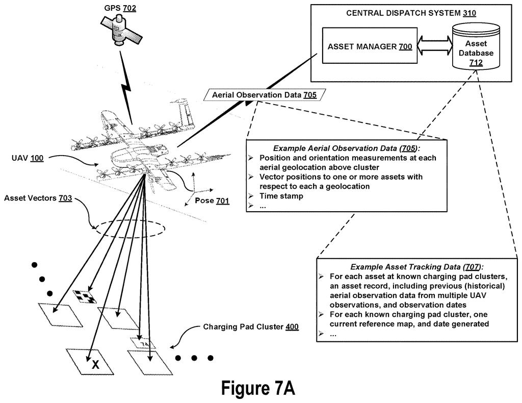
What Wing's drones notice about charging pads
You run a store with a row of drone charging pads out back. Over a few weeks someone shifts one pad, and a painted ground marker gets scuffed away. Nobody files a report, and the delivery drones still expect the old layout. This Wing patent application tries to fix that by having the drones notice changes on their own.
Each time a drone flies over the pads, its camera spots every pad and marker it can see and works out where each one sits relative to the drone. It sends those compact position notes to a server, which stitches notes from different flights into one top-down map.
Then the server compares that fresh map with the previous one. If something moved, vanished or showed up, the record for that site gets updated, and drones can use the corrected map on their next landing.
… generating, based on the map graph, a current spatial map of the subset of the cluster assets; detecting a configuration change in the ground-based asset cluster by comparing the current spatial map to a prior spatial map of the ground-based asset cluster; and updating a database record associated with the ground-based asset cluster based on the configuration change.
Translation: The system makes a map, compares it to an older one to spot any changes, and updates its database records.
How Wing turns drone photos into a distance map
Claim 1 covers a computer method that starts with data from an aerial vehicle looking down at a ground-based asset cluster, meaning a group of ground equipment with fiducial markers (simple visual tags, similar to low-resolution QR codes, that a camera can recognize) scattered across it. The data has two parts: where the aircraft was, and vector positions (the direction and distance from the aircraft to each asset it spotted).
A server turns that into a map graph: a web of dots for each aircraft position and each spotted asset, joined by lines that stand for distances. The description pictures those lines as springs that are stiffer when a measurement is more certain, since GPS drift, wind and weather make some readings shakier. Adjusting the web until it settles into a consistent layout (the filing calls this optimizing) produces a spatial map. That fine-tuning appears in dependent claims, not claim 1.
The core of claim 1 comes next:
- Compare the current spatial map with a prior one.
- Detect a configuration change in the cluster.
- Update a database record for that cluster.
Dependent claims add several options. Maps from several drones can be averaged, odd readings can be discarded, and a cluster the system has never seen can be added to the database. The markers do not need to be unique, because the map tells identical ones apart by how they sit relative to each other. The description adds that drones boil images down to small numbers, so uploads over a cellular connection stay cheap.
A computing system in an infrastructure support network for uncrewed aerial vehicles (UAVs) may receive, from a UAV, aerial observation data of a ground-based cluster of charging pads for UAVs, the cluster comprising assets including the charging pads arranged in a layout and fiducial markers distributed across the layout.
Translation: A computer network gets data from a drone about a group of charging pads and visual markers on the ground.
Why Wing wants landing maps that stay current
The practical payoff is drones landing on the right pad. In the filing's own hypothetical example, GPS alone puts a drone within about 3 meters of its target 99% of the time, and roughly 7% of the time the closest pad could be the wrong one. Ground markers help a drone tell pads apart, but only if its map of those markers still matches reality. A pad that gets shifted or a marker that gets damaged would make the map stale.
The filing also treats a detected change as a signal that a site may need on-site maintenance. And because regular delivery flights supply the observations, an operator would not need survey crews to revisit sites with 10 to 50 or more pads each. This is a patent application describing a method, not a launched product.
Google's 25th filing in our Robotics coverage since May follows plain-English robot dog commands and cargo-swapping truck stops among the patents we've tracked.
Claim 1 is wider than the headline idea suggests. It says "aerial vehicle," so any flying machine with a camera fits, and it says "ground-based asset cluster," so the equipment on the ground can be anything with markers among it. Charging pads and payload loaders only appear later, in claim 17.
The claim does demand a specific chain of steps: marker-based observations, a map built from dots and distance lines, a comparison against an earlier map, and a database update. The spring-style fine-tuning that gets most of the description's attention sits in dependent claims 8 and 14, so the core claim does not depend on that math.
If granted, it would reach any operator that tracks marked ground equipment by flying over it and comparing maps over time. It is careful bookkeeping for a drone network, and most people will never see it. A customer would notice only that the package lands on the right pad.
Get our take in your Top Stories
Liked this breakdown? Add Patentlyze as a preferred source on Google, and our plain-English take shows up more often in your Top Stories the next time Google patent news breaks.
There are more where this came from
We read every patent application Big Tech publishes and send you the ones worth knowing. Plain English, free, every week.
The drawings
18 drawing sheets from US 2026/0348739 A1 · click any drawing to enlarge


Show the other 10 sheets


Want this weekly breakdown for a company we don't cover? Patentlyze Pro →
Be the first to weigh in