
Qualcomm
Qualcomm · Automotive · Filed Jun 13, 2025 · USPTO published Nov 12, 2026 · This week's release
Qualcomm Patents a Method to Match Live Driving Data With Precise Navigation Charts
A car's own sensors see the road a little differently than the expensive reference map does. Qualcomm's patent application fixes that mismatch by boiling both down to stick-figure road diagrams and lining up the intersections.
- Publication number
- US 2026/0358139 A1(US20260358139A1)
- Applicant
- QUALCOMM Incorporated
- Filed · Published
- Jun 13, 2025 · Nov 12, 2026
- Inventors
- Yufeng HE, Ling CHEN, Xinyu LIN, Xuemei ZHENG
- Status when we published
- Approved; patent expected soon
- Document
- 20 claims
- US classification
- 701/450
- Examiner
- ARTHUR JEANGLAUDE, GERTRUDE (Art Unit 3661)
- Parent application
- National Stage Entry of PCT/CN2023/078631 (filed Feb 28, 2023)(PCTCN2023078631)
What Qualcomm's road-skeleton matching does
You're riding in a car that scans the road with lasers as it goes. The scan looks like a road, but it's a little off: shifted a few feet, maybe tilted. Meanwhile the mapping company has a far more precise reference map of the same streets.
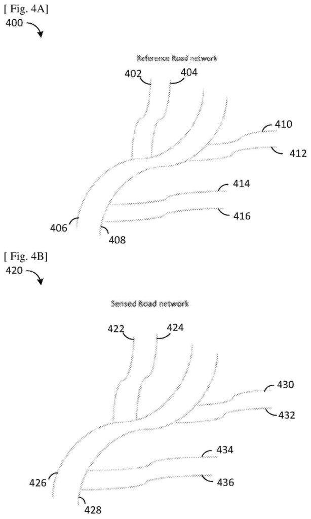
Qualcomm's idea is to avoid comparing millions of individual points one by one. Instead, the system strips each map down to a simple skeleton: lines for roads, dots for intersections. It matches the dots between the two skeletons, then matches the roads between them.
Once it knows which road is which, it compares the detailed points along each one and nudges the car's scan into place. The scan gets moved and turned, but its overall shape stays intact. The corrected data can then go back to the car for navigation and driving decisions.
generate a reference skeleton model based on a first dataset; obtain a second dataset associated with the road network; generate a sensed skeleton model based on the second dataset; …
Translation: The system creates baseline map models and compares them against live sensor data from vehicles.
How intersections guide the map alignment
The patent describes a system that registers (lines up) two 3D maps of the same road network: a sensed map built from a vehicle's sensors, such as LIDAR (a laser scanner that measures distance to objects), and a reference map, a high-definition 3D map with centimeter-level accuracy.
First, each map is simplified and then thinned into a skeleton model using standard shape-thinning methods (such as a medial axis transform, which finds the centerline of a shape). Roads become lines, and intersections become nodes. The system then reads the topology (how the nodes and lines connect) of each skeleton.
Next it works in two passes:
- Rough match: pair up nodes by position, then use those pairs to pair up road lines.
- Fine match: for each paired road, match individual 3D points and measure how far apart each pair sits. A sliding window (a small viewing frame moved along the road) produces several readings per point, and a voting step picks the smallest deviation.
Finally, an optimizer rotates and shifts the sensed points to shrink the average error, keeping the distances and angles between the points unchanged so the scan's shape isn't warped.
… perform operations that adjust a positioning of one or more data points of the second dataset based at least on the one or more nodes of the first topology and the one or more nodes of the second topology.
Translation: It corrects the location of live driving data to make sure it matches up precisely with high definition maps.
Why this matters for car maps and lane choices
The practical payoff is a car whose own scans agree with the precise map it relies on. The filing says the corrected data can update the maps on a device and adjust vehicle settings such as path planning, lane centering, lane selection and speed. It also targets a known headache: matching huge maps in tiles can give inconsistent results at the tile edges.
The patent office has approved this application, and once Qualcomm pays the final fee it should be issued as a granted patent. For you, it would show up only as maps and lane guidance that drift less, not as a feature you'd ever see on a screen.
Qualcomm's 58th filing we've tracked since July in our self-driving sensing race watchlist builds on earlier work like one skipping fixed road grids and one deprioritizing parked cars.
Source: US 2026/0358139 A1 at the USPTO (PDF). Full patent text and figures are in the official publication.
Get our take in your Top Stories
Liked this breakdown? Add Patentlyze as a preferred source on Google, and our plain-English take shows up more often in your Top Stories the next time Qualcomm patent news breaks.
Add Patentlyze on Google
One click.
There are more where this came from
We read every patent application Big Tech publishes and send you the ones worth knowing. Plain English, free, every week.
The drawings · 7 sheets
7 drawing sheets from US 2026/0358139 A1 · click any drawing to enlarge


More from Qualcomm
All 624 Qualcomm patents →
More in Automotive
All 360 Automotive patents →
Nvidia
Nvidia Files Patent for Counting Each Object Once When Several Car Cameras See It
Waymo (Google)
Waymo Files Patent for Self-Driving Cars That Zoom In on Brake Lights
Waymo (Google)
Waymo Files Patent for a Car That Notices When a Pedestrian Starts to Fall
Waymo (Google)
No comments yet