
Waymo · Filed Dec 19, 2025 · Published Nov 5, 2026

Waymo Files Patent for Cars That Find Their Own Stop Spot Without a Painted Line

Plenty of residential streets have a stop sign and no painted line, so Waymo's patent teaches its cars to pick a sensible stopping spot the way a careful human driver would.
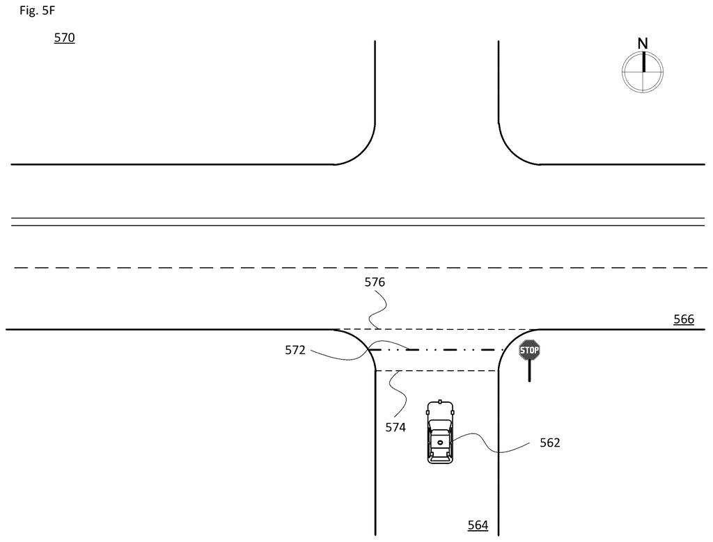
A driverless car projects virtual stopping lines across an intersection when there is no painted line on the pavement. Drawing from patent filing US 2026/0351011 A1.
A driverless car projects virtual stopping lines across an intersection when there is no painted line on the pavement.
See all 35 drawings from this filing ↓
Publication number US 2026/0351011 A1 US20260351011A1
Applicant WAYMO LLC
Filing date Dec 19, 2025
Publication date Nov 5, 2026
Inventors Romain Thibaux, David Harrison Silver, Congrui Hetang
US classification 382/104
Status when we published Waiting for an examiner (Jul 25, 2026)
Parent application is a Continuation of 18403316 (filed 2024-01-03)
Document 20 claims

What Waymo's no-stop-line patent actually does

You're riding in a self-driving car, and it rolls up to a stop sign on a residential street. There's no painted line on the pavement. A human driver would eyeball it: stop near the corner, far enough forward to see cross traffic, but not so far that you're sitting in the intersection.

Waymo's patent teaches the car to make that same judgment call. When its sensors spot a stop sign, a signal, or a crosswalk but no stop line, a trained neural network (software that learns patterns from huge piles of examples) predicts where the car should stop. It can weigh things like the curve of the curb and what other road users are doing.

The car then stops at that spot. The filing also describes saving the result to a shared map, so other cars in the fleet know about it too.

From the filing · CLAIM 1
… determining, by the one or more processors, whether the sensor data includes an indicia of a requirement for the vehicle to stop or yield without a corresponding stop line at which to stop or yield; …

Translation: The car looks for signs it needs to stop even when there is no painted line on the street.

How the car guesses a stop spot from sensors

The claims cover a car that first checks its sensor data for a sign that it must stop or yield. The data comes from at least two different types of sensors, such as lidar (which bounces lasers off objects to measure distance) and cameras. The sign can be a traffic signal, stop sign, yield sign, crosswalk, or text on the road, with no stop line to go with it.

When that happens, a neural network (software trained on millions of examples to recognize patterns) predicts one or more stop locations, and the car stops at the chosen one. The filing describes the network producing three outputs:

  • Classification: a yes/no heat map of whether a stop line is nearby.
  • Localization: arrows from each pixel pointing to the nearest point on a stop line.
  • Uncertainty: a spread of possible stop spots, wider and blurrier when no line is painted.

With no line, the car can use the shape of the curb or intersection, its own size, how much it can see from the spot, and what other road users do. In one example it picks a point halfway along the curve of the corner, then may edge forward to see past a tree. The check switches on when the car is roughly 4 to 15 meters from the end of its lane, depending on vehicle size.

From the filing · THE ABSTRACT
Even if a stop line is present, the physical location may not match what is in store map data, which may be out of date due to construction or line repainting.

Translation: Painted lines often fail to match digital maps because roads change due to construction.

Why stale maps are a problem for Waymo's cars

Where a car stops matters more than it sounds. Stop too far back and it can't see cross traffic. Stop too far forward and it blocks the intersection. Maps that record the right spot go stale whenever a crew repaints a line or reshapes a corner, and plenty of streets never had a line at all.

The filing also describes writing the chosen spot back into the map and sharing it with the rest of the fleet, so one car's discovery can help every other car. The description covers passenger cars, delivery vehicles and big trucks alike. If it works, you would likely never notice it. You would just get a ride that stops where a careful driver would.

Google's 75th filing we've tracked since May in our robotaxi sensing watchlist follows one on brake glitch filtering and one on audio taxi directions.

Editorial take

Every choice here swaps certainty for flexibility. A map says exactly where to stop, but only until a crew repaints a line or reshapes a corner, while a neural network can handle the changed intersection by making a judgment call. The filing admits the cost: for unmarked corners its output is a wider, blurrier spread of possible spots than for a painted line.

That cost shows up in two places. A car that stops too far back may not see cross traffic, and one that stops too far forward sits in the intersection. If a bad guess is then written into a map the whole fleet reads, the mistake could travel with it. The filing's answer is to measure the car's own doubt and flag a change only when the mapped spot looks unlikely given that doubt.

The trade reads as worth it. Streets change faster than maps get redrawn, and a system that knows how unsure it is looks like a sensible price for handling corners nobody painted.

Get our take in your Top Stories

Liked this breakdown? Add Patentlyze as a preferred source on Google, and our plain-English take shows up more often in your Top Stories the next time Google patent news breaks.

There are more where this came from

We read every patent application Big Tech publishes and send you the ones worth knowing. Plain English, free, every week.

The drawings

35 drawing sheets from US 2026/0351011 A1 · click any drawing to enlarge

Sensors mounted on a self-driving minivan, drawing sheet 1 from US 2026/0351011 A1
Sheet 1 Sensors mounted on a self-driving minivan
Roof and body sensors on an autonomous sedan, drawing sheet 2 from US 2026/0351011 A1
Sheet 2 Roof and body sensors on an autonomous sedan
Autonomous semi truck with sensors on cab and trailer, drawing sheet 3 from US 2026/0351011 A1
Sheet 3 Autonomous semi truck with sensors on cab and trailer
Computer systems that steer and brake a passenger vehicle, drawing sheet 4 from US 2026/0351011 A1
Sheet 4 Computer systems that steer and brake a passenger vehicle
Control systems and navigation hardware inside an autonomous truck, drawing sheet 5 from US 2026/0351011 A1
Sheet 5 Control systems and navigation hardware inside an autonomous truck
Electrical control parts and sensors built into a trailer, drawing sheet 6 from US 2026/0351011 A1
Sheet 6 Electrical control parts and sensors built into a trailer
Road view with clearly painted stop markings, drawing sheet 7 from US 2026/0351011 A1
Sheet 7 Road view with clearly painted stop markings
Road intersection marked only by a sign without paint, drawing sheet 8 from US 2026/0351011 A1
Sheet 8 Road intersection marked only by a sign without paint
Show the other 27 sheets
Approaching a painted stop line at a signalized intersection, drawing sheet 9 from US 2026/0351011 A1
Sheet 9 Approaching a painted stop line at a signalized intersection
Matching the target stop line across the entire road lane, drawing sheet 10 from US 2026/0351011 A1
Sheet 10 Matching the target stop line across the entire road lane
Nearing a stop sign at an unmarked junction, drawing sheet 11 from US 2026/0351011 A1
Sheet 11 Nearing a stop sign at an unmarked junction
Setting a virtual stop line aligned with cross street curbs, drawing sheet 12 from US 2026/0351011 A1
Sheet 12 Setting a virtual stop line aligned with cross street curbs
Driving up to an unlined corner with curved curbs, drawing sheet 13 from US 2026/0351011 A1
Sheet 13 Driving up to an unlined corner with curved curbs
Calculating a safe stopping range along rounded street corners, drawing sheet 14 from US 2026/0351011 A1
Sheet 14 Calculating a safe stopping range along rounded street corners
Creeping forward past roadside bushes for a clear view, drawing sheet 15 from US 2026/0351011 A1
Sheet 15 Creeping forward past roadside bushes for a clear view
Navigating a busy intersection filled with crosswalks and cyclists, drawing sheet 16 from US 2026/0351011 A1
Sheet 16 Navigating a busy intersection filled with crosswalks and cyclists
Merging laser and camera data to spot road markings, drawing sheet 17 from US 2026/0351011 A1
Sheet 17 Merging laser and camera data to spot road markings
Scanning around a stop line to check for paint, drawing sheet 18 from US 2026/0351011 A1
Sheet 18 Scanning around a stop line to check for paint
Pointing each grid square toward the nearest road line, drawing sheet 19 from US 2026/0351011 A1
Sheet 19 Pointing each grid square toward the nearest road line
Guiding the vehicle toward the exact stopping edge, drawing sheet 20 from US 2026/0351011 A1
Sheet 20 Guiding the vehicle toward the exact stopping edge
Narrowing the target zone to a single thin stop boundary, drawing sheet 21 from US 2026/0351011 A1
Sheet 21 Narrowing the target zone to a single thin stop boundary
Teaching the car to recognize stop zones and direction vectors, drawing sheet 22 from US 2026/0351011 A1
Sheet 22 Teaching the car to recognize stop zones and direction vectors
Placing a search box to find painted pavement, drawing sheet 23 from US 2026/0351011 A1
Sheet 23 Placing a search box to find painted pavement
Comparing sharp stop lines with wider zones of uncertainty, drawing sheet 24 from US 2026/0351011 A1
Sheet 24 Comparing sharp stop lines with wider zones of uncertainty
Calculating the probability curve for a stop location, drawing sheet 25 from US 2026/0351011 A1
Sheet 25 Calculating the probability curve for a stop location
Projecting sensor data onto the lane line, drawing sheet 26 from US 2026/0351011 A1
Sheet 26 Projecting sensor data onto the lane line
Measuring distance between detected and mapped stops, drawing sheet 27 from US 2026/0351011 A1
Sheet 27 Measuring distance between detected and mapped stops
Comparing confidence zones for painted and unpainted stops, drawing sheet 28 from US 2026/0351011 A1
Sheet 28 Comparing confidence zones for painted and unpainted stops
Training an AI to update digital road maps, drawing sheet 29 from US 2026/0351011 A1
Sheet 29 Training an AI to update digital road maps
Activating stop line detection as the car approaches, drawing sheet 30 from US 2026/0351011 A1
Sheet 30 Activating stop line detection as the car approaches
Filtering candidate stop points to find the true line, drawing sheet 31 from US 2026/0351011 A1
Sheet 31 Filtering candidate stop points to find the true line
Connecting autonomous vehicles with fleet servers and users, drawing sheet 32 from US 2026/0351011 A1
Sheet 32 Connecting autonomous vehicles with fleet servers and users
Connecting autonomous vehicles with remote assist desks and servers, drawing sheet 33 from US 2026/0351011 A1
Sheet 33 Connecting autonomous vehicles with remote assist desks and servers
Teaching the computer model to map the best stop locations, drawing sheet 34 from US 2026/0351011 A1
Sheet 34 Teaching the computer model to map the best stop locations
How the car predicts stopping spots at intersections, drawing sheet 35 from US 2026/0351011 A1
Sheet 35 How the car predicts stopping spots at intersections
Browse all the drawings 35 drawing sheets
Patent filing page

Source. Full patent text and figures from the official USPTO publication PDF.
Reader comments

Be the first to weigh in

Start the discussion

Real name or a handle, either is fine. Comments are read by a person before they appear, so allow a little time. Keep it about the filing.