
Google Patents a Privacy-First Way to Show Live Crowd Levels at Public Places
Google Maps already shows you how busy a coffee shop typically gets on a Tuesday afternoon. A new patent describes a system for showing you how busy it is right now, built around a set of privacy guardrails designed to prevent individual people from being tracked.
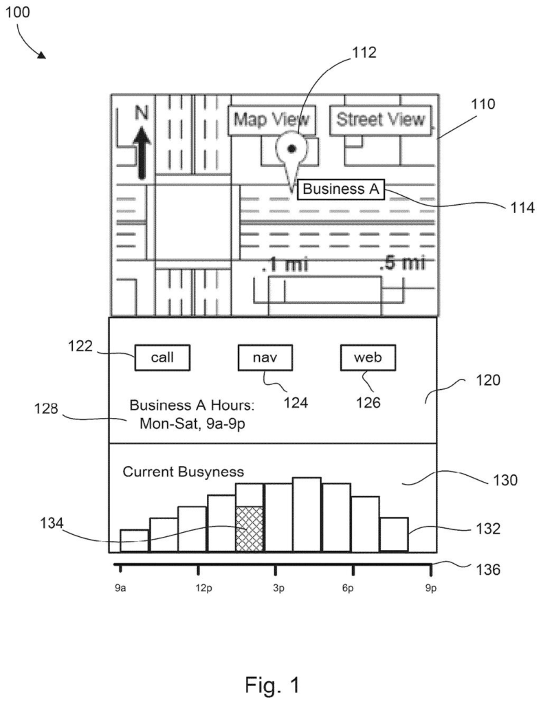
What Google's real-time busyness system actually does
Ever wondered if the gym or the DMV is slammed before you leave the house? That's the problem this patent tries to solve.
Google Maps has long shown historical busyness, the kind that tells you a restaurant is usually packed at noon on Fridays. This patent describes a system for generating a live crowd count using location signals from phones that have opted into sharing their location. Crucially, before any busyness figure goes public, the system runs two checks: are enough people contributing data to protect individual privacy, and does the live number actually line up with what history would predict? If either check fails, the real-time figure is withheld.
The practical result for you: a crowd bar or percentage you can trust, shown alongside the usual historical chart, so you can decide whether to head out now or wait an hour.
… aggregating, in real time at the one or more processors, the unique identifiers in a data structure, wherein the aggregating avoids duplicating any of the unique identifiers in the data structure; …
Translation: The system counts unique phone signals on site without double counting anyone.
How Google counts phones without tracking people
The patent describes a pipeline with four key steps.
- Collect unique identifiers in real time: When mobile devices share location and put a user near a specific public place, their device sends a unique ID to Google's servers. The system deduplicates these IDs in a data structure, so one person walking past three times counts as one person, not three.
- Privacy qualification: The system checks whether enough distinct devices are present to make the data aggregate-safe. If the pool is too small, individual users could theoretically be identified, so the system suppresses the result entirely.
- Accuracy qualification: The computed live count is compared against historical busyness data for that place and time. If the live figure is wildly inconsistent with the historical baseline, it's flagged as likely unreliable and also suppressed.
- Output: Only when both checks pass does the real-time busyness figure get sent to Maps or another application for display.
The two-gate system means a nearly empty parking lot at 2 a.m. (too few devices to be private) and a suspiciously anomalous spike on a Tuesday (possibly a data artifact) would both be filtered out before reaching users.
… whether the computed real-time busyness information is accuracy-qualified, based on a comparison of the real-time busyness information to historical busyness information.
Translation: It checks if the current crowd size makes sense compared to normal past trends.
What this means for Maps users checking busy spots
For everyday Maps users, this is the difference between guessing and knowing. Historical busyness tells you what usually happens; live busyness tells you what's happening right now. That matters most in unpredictable situations like post-storm traffic at a grocery store, a surprise event near a transit hub, or any place whose patterns aren't regular.
the pattern in Google's location-privacy filings points toward making opt-in location data more useful without expanding what the company knows about any one person. The dual-qualification approach described here is a meaningful structural answer to a legitimate concern: that any system counting people in a place can, if poorly designed, reveal individual movements.
Google's 51st filing we've tracked since May continues a pattern seen in earlier applications like training AI on your phone and keeping power grid data private, all part of our on-device AI privacy watch.
The two-gate design is the interesting part here. Most systems that aggregate location data focus on one problem at a time, either privacy or accuracy. Building both checks into the pipeline before anything reaches the user is a cleaner architecture than patching one on later.
From a user standpoint, the payoff is modest but real. You'd notice it most on the days historical data is useless: the day after a holiday, a surprise road closure, or a local event that drew an unexpected crowd. Those are exactly the moments a typical Tuesday-at-noon estimate fails you.
The privacy framing does double duty here. It protects users, and it also gives Google a defensible answer to regulators who increasingly scrutinize what location-data systems infer about individuals. Whether those guardrails hold up to real-world pressure is a question no patent can answer.
There are more where this came from
We read every patent application Big Tech publishes and send you the ones worth knowing. Plain English, free, every week.
The drawings
8 drawing sheets from US 2026/0289588 A1 · click any drawing to enlarge


Want this weekly breakdown for a company we don't cover? Patentlyze Pro →
Be the first to weigh in