
Qualcomm Patents Technology That Updates Wireless Coverage Maps With Precision Detail
Qualcomm wants to fix the weak spots in the 3D models that cellular networks use to predict radio coverage, not by rebuilding the whole map, but by surgically upgrading only the parts that matter most.
How Qualcomm's selective 3D map upgrades work
Imagine you're trying to predict where your phone signal will drop inside a dense city block. Engineers already build rough 3D computer models of neighborhoods to simulate how radio waves bounce off buildings, but those models are often too coarse to catch the spots where signal actually fails.
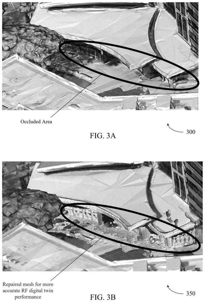
Qualcomm's patent describes a system that starts with one of those rough 3D maps and then identifies which specific patches of it have the biggest effect on wireless coverage predictions. Only those patches get swapped out for much more detailed geometry data. Think of it like replacing a smudged section of a city map with a high-resolution satellite photo, while leaving the rest of the map as-is.
The result is a "digital twin" of the real world that's accurate where it counts, without the cost of scanning every street corner at maximum detail. That kind of targeted precision could help carriers figure out where to place antennas, or help predict dead zones before they annoy your call.
… select one or more regions of the initial 3D model to be updated with enhanced physical characteristics relative to corresponding physical characteristics in the initial 3D model, the one or more regions selected based at least in part on an associated impact to the RF model; …
Translation: The system picks specific areas to upgrade based on how much they affect wireless signal performance.
How the system picks regions and pulls richer geometry
The patent centers on what Qualcomm calls an RF model, a simulation of how radio frequency signals travel through a real physical space. To build that simulation, you need a 3D representation of the environment: buildings, walls, terrain. This is the "digital twin."
The process the patent describes has four main steps:
- Start with a coarse 3D model of a neighborhood or locality, where every region already has some basic signal-propagation properties attached to it.
- Score each region by how much impact it has on the overall RF model's accuracy. Regions with low-fidelity geometry that also happen to sit in signal-critical areas get flagged for upgrade.
- Pull in higher-fidelity 3D data for only those flagged regions, think LIDAR scans or photogrammetry data (detailed point-cloud measurements taken from cameras or lasers) rather than generic building footprints.
- Merge the detailed patches back into the original model to produce an "adapted" digital twin that's sharper where it matters.
The selection step is the key engineering contribution. Rather than spending compute on uniform high-detail coverage, the system prioritizes regions whose physical inaccuracies would most distort the signal prediction. That makes the workflow practical at city scale, where scanning everything at maximum fidelity would be prohibitively expensive.
Various aspects relate to RF models based on digital twins, where one or more regions of a digital twin may be adapted to incorporate higher fidelity data than other portions of the digital twin.
Translation: The technology uses detailed virtual replicas of real world environments to improve wireless coverage maps.
What better signal maps mean for 5G network planning
Wireless carriers spend enormous amounts of money figuring out where to put cell towers and small cells, and a large part of that cost is the simulation work done before a single piece of hardware goes up. If those simulations are based on rough 3D maps, the predictions can be wrong enough to cause real coverage gaps after deployment, which then require expensive field corrections.
Qualcomm supplies the chips inside base stations and the modeling software that runs on top of them, so accurate RF simulation is directly tied to how well its products perform in the real world. A filing like this one sits in the quieter, infrastructure-planning corner of Big Tech patent news on wireless and chip design, where improvements in 5G planning tools are accumulating steadily even if they rarely make consumer headlines.
This is the 343rd Qualcomm filing in our Qualcomm coverage since May, adding to work that includes the folding screen buttons patent and the self-correcting AI vision patent.
The problem this patent attacks is real and measurable. Cellular carriers routinely discover after deployment that signal coverage doesn't match pre-build simulations, and the root cause is often that the 3D environment models used during planning were too coarse in precisely the spots where geometry matters most. Fixing that after the fact means truck rolls, hardware moves, and reconfiguration costs that add up fast.
The approach here is sensible: instead of demanding higher-fidelity data everywhere (which is expensive to collect and slow to process), the system asks which regions actually change the answer. That's a practical engineering trade-off rather than a speculative one.
Where the filing is less dramatic is in its novelty. Selective refinement of simulation models based on sensitivity analysis is a well-established idea in computational engineering broadly. The patent's value will depend on how specifically Qualcomm has defined the RF-domain criteria for region selection, and that detail lives in the claims, not the abstract.
Get our take in your Top Stories
Liked this breakdown? Add Patentlyze as a preferred source on Google, and our plain-English take shows up more often in your Top Stories the next time Qualcomm patent news breaks.
There are more where this came from
We read every patent application Big Tech publishes and send you the ones worth knowing. Plain English, free, every week.
The drawings
10 drawing sheets from US 2026/0253352 A1 · click any drawing to enlarge


Show the other 2 sheets


Want this weekly breakdown for a company we don't cover? Patentlyze Pro →
Be the first to weigh in