
Google Files Patent for an AI System That Answers Map Questions Using Satellite Data
Ask a map how many trees are in a park, and this patent has a chain of AI models figure out which satellite photos and databases to check. The filing's own example answer: about 235,000 trees in Louisville's Cherokee Park.
What X Development's map-question AI actually does
Right now, answering a question like "how many trees are in Cherokee Park?" usually takes an expert. A geospatial data scientist has to work out which maps, satellite photos and databases to use, then write the code to pull them together. That takes real time, and the result often only works for that one question.
This patent application from X Development, part of Alphabet, hands that job to a chain of AI models. You type or say your request. One model sketches a plan, another picks which datasets to use, and a third writes the database commands that fetch the answer. The result then shows up on your screen, maybe as a number or as marks drawn on your map.
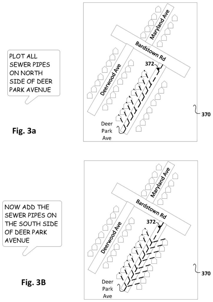
If the answer isn't quite what you wanted, you can follow up in plain English, like asking it to add the other side of the street.
processing a natural language request based on one or more generative models to generate workflow output tokens that identify high-level actions for completing a geospatial task conveyed in the natural language request …
Translation: The system uses AI to figure out what map related task a user is asking for in plain English.
How three AI models hand off to a database
The claimed method runs in three AI passes, each feeding the next. A model first reads your natural language request and produces workflow output tokens (the chunks of text a language model writes), which spell out the high-level steps for the task.
- Plan: the request becomes a list of steps, such as "find a tree inventory database" or "run an image-recognition model on satellite photos."
- Pick the data: a second pass reads those steps plus metadata (descriptions and layouts) for the datasets available to you, then chooses the ones likely to hold the answer. It can score each dataset for usefulness.
- Write the query: a third pass produces SQL (the standard language for asking databases questions), which is then run against the chosen datasets.
The response, or data derived from it, is shown on your device. If the generated SQL fails a check, such as running without error, the system sends it back to a model along with a note about what went wrong and gets a rewrite. When two databases are involved, the SQL can join them.
The description also covers other kinds of data: overhead images from satellites or drones with labeled land features, and maps that can be lined up and overlaid. Follow-up requests can reuse results from earlier turns.
… generate data manipulation output tokens that identify data manipulation instructions for assembling data from the responsive dataset(s) into a response that fulfills the geospatial task …
Translation: It writes computer code to pull together the right satellite data and answer the user question.
What this means for asking maps questions
If this worked as described, you wouldn't need a data scientist to compare maps, satellite photos and databases. You would ask in a chat box inside a mapping app, as the filing describes, and refine the answer with follow-up questions. The filing's examples include plotting sewer pipes on one side of a street and showing human-caused methane leaks across New Hampshire.
For anyone sitting on piles of location data, such as city departments, researchers or land managers, the bottleneck is often the person who knows how to connect it all. This filing aims at that step. It is a patent application, so it says nothing about whether any product is coming.
Google's 31st filing we've tracked since May on AI working in teams follows industry-tuned ad AI and big models writing small ones, adding another piece to how the company imagines AI agents splitting tasks.
The shortest route to a product here is all software. The filing needs no new hardware: it chains language models that already exist to database commands that already exist, and it puts the result in a chat box on a mapping app. That makes this a short hop compared with most patents.
The hard part is trust. The retry loop the filing describes checks whether the generated code runs without error. A query can run cleanly and still return a wrong number, and a tree count of 235,000 is only useful if you believe it. The filing also leans on well-described datasets, with human-written notes and clear database layouts, and a company would need those in place first.
The verdict: a sensible, buildable idea whose real test is accuracy, not engineering. Expect the first useful versions to work on tidy, well-labeled data like a city's sewer map, long before they handle messy satellite counting.
Get our take in your Top Stories
Liked this breakdown? Add Patentlyze as a preferred source on Google, and our plain-English take shows up more often in your Top Stories the next time Google patent news breaks.
There are more where this came from
We read every patent application Big Tech publishes and send you the ones worth knowing. Plain English, free, every week.
The drawings
5 drawing sheets from US 2026/0320104 A1 · click any drawing to enlarge


Want this weekly breakdown for a company we don't cover? Patentlyze Pro →
Be the first to weigh in