Get the newsletter
Mobileye (Intel) · Automotive · Filed Jan 29, 2026 · USPTO published Nov 19, 2026 · This week's release

Mobileye Files Patent for Building Intersection Maps From Other Cars' Drives

Every intersection is really many roads in one, since each entrance can lead to several exits. Mobileye's patent application describes a way to map each of those turns separately and then line them up so they agree.
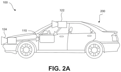
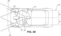
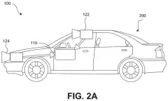
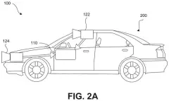
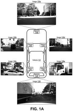
A passenger car carries forward-facing cameras on its bumper and windshield to record the road ahead for onboard driving software. Drawing from patent filing US 2026/0366886 A1.
A passenger car carries forward-facing cameras on its bumper and windshield to record the road ahead for onboard driving software.All 73 drawings ↓
Publication number
US 2026/0366886 A1(US20260366886A1)
Applicant
Mobileye Vision Technologies Ltd.
Filed · Published
Jan 29, 2026 · Nov 19, 2026
Inventors
Gideon WACHTEL, Yoav TAIEB, Yahel GUBERMAN, Ofer FRIDMAN, Raz Cohen MASLATON, Moshe SHENFELD, Ori SEGEL, Ofer SPRINGER
Status when we published
Waiting for an examiner
Document
20 claims
US classification
701/28
Parent application
Continuation of 17/824,264 (filed May 25, 2022)(17824264)

What Mobileye's intersection mapping patent does

You're stopped at a wide intersection. The car in front of you turns left, the one beside you goes straight, and you're about to turn right. Each of you takes a different path through the same patch of pavement, and a self-driving system needs to know every one of those paths.

Mobileye's filing describes a mapping system that collects short drive reports from lots of cars with cameras. Each report includes landmarks the camera spotted (a stop sign, a light pole, a crosswalk) and the route that car took. The system sorts the cars by which entrance and exit they used, boils each group down to one target path, then lines the paths up using landmarks the groups both saw.

The finished map goes out to other cars, which use it to get through the intersection. It stays small on purpose, storing paths and a few landmarks instead of full pictures.

From the filing · CLAIM 135
receive drive information from each of a plurality of vehicles that traverse a road junction, the road junction including a plurality of entrances and one or more exits associated with each one of the plurality of entrances …

Translation: The system collects driving data from many different cars driving through the same intersection.

How cars' drives get sorted by entrance and exit

The patent describes a sparse map generator, a server-side system that builds lightweight maps for self-driving and driver-assist cars. It collects drive information from many vehicles that pass through the same road junction. Each report holds two things: 3D feature points (spots on objects the camera saw, each with a position in the image and a distance from the camera) and the trajectory (the path) that car followed.

The filing says that distance can come from tracking an object across several frames and using the car's own motion (ego motion, meaning how the car itself moved between frames). Then come the claimed steps:

  • Sort the cars into groups by entrance-exit combination, such as everyone who came in from the south and left to the east.
  • For each group, merge the points into combined 3D feature points and build a target trajectory, which a dependent claim says can be the group's average path.
  • Line up the target trajectories using the combined points that show up in both groups.
  • Build the sparse map with the aligned paths and send it to other vehicles.

The objects can be traffic lights, stop signs, stop lines, light poles, road markings, crosswalks, buildings or curbs. Camera position can come from GPS or from ego motion. The filing also describes versions where cars driving in opposite directions, or a rear-facing camera, help line things up.

From the filing · THE ABSTRACT
… cause transmission of drive information for the road segment to an entity remotely-located relative to the host vehicle, wherein the drive information includes the identified at least one position descriptor associated with each of the detected one or more semantic features, the identified three-dimensional feature points, and the position information …

Translation: The car uploads its collected road data and object locations to a remote server for mapmaking.

Why crowdsourced intersection maps matter for Mobileye

If you ride in a car with driver assistance, a lot depends on the car knowing where to go in the messiest spots on the road. An intersection can offer many different routes, and a map that records each one separately could drift out of agreement with itself. This filing tackles that by lining every route up against the same landmarks.

The approach also leans on reports from ordinary cars with cameras, and the filing says keeping the map small (paths and a few landmarks instead of detailed images) cuts the cost and time of sending map data to cars. The filing names Mobileye's own EyeQ vision chips as example hardware, so the company's chips are part of the picture.

That makes this Intel's 11th filing we've tracked since September in the self-driving sensing race, a group that includes their laser sensor interference fix and Mobileye's sharper radar with fewer antennas.

Source: US 2026/0366886 A1 at the USPTO (PDF). Full patent text and figures are in the official publication.

Get our take in your Top Stories

Liked this breakdown? Add Patentlyze as a preferred source on Google, and our plain-English take shows up more often in your Top Stories the next time Intel patent news breaks.

There are more where this came from

We read every patent application Big Tech publishes and send you the ones worth knowing. Plain English, free, every week.

The drawings · 73 sheets

73 drawing sheets from US 2026/0366886 A1 · click any drawing to enlarge

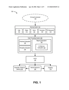
Main computer parts that handle mapping and camera feeds, drawing sheet 1 from US 2026/0366886 A1
Sheet 1 Main computer parts that handle mapping and camera feeds
Placing cameras by the rearview mirror and front bumper, drawing sheet 2 from US 2026/0366886 A1
Sheet 2 Placing cameras by the rearview mirror and front bumper
Offsetting a bumper camera from a windshield camera, drawing sheet 3 from US 2026/0366886 A1
Sheet 3 Offsetting a bumper camera from a windshield camera
Mounting two cameras side by side behind the windshield, drawing sheet 4 from US 2026/0366886 A1
Sheet 4 Mounting two cameras side by side behind the windshield
Widening coverage with cameras placed near both headlights, drawing sheet 5 from US 2026/0366886 A1
Sheet 5 Widening coverage with cameras placed near both headlights
Grouping three cameras together behind the windshield, drawing sheet 6 from US 2026/0366886 A1
Sheet 6 Grouping three cameras together behind the windshield
Sending driving commands to gas, brakes, and steering, drawing sheet 7 from US 2026/0366886 A1
Sheet 7 Sending driving commands to gas, brakes, and steering
Cabin dashboard controls and a mirror-mounted camera position, drawing sheet 8 from US 2026/0366886 A1
Sheet 8 Cabin dashboard controls and a mirror-mounted camera position
Show the other 52 sheets
Three windshield cameras angled inside a protective glare shield, drawing sheet 9 from US 2026/0366886 A1
Sheet 9 Three windshield cameras angled inside a protective glare shield
Front view of the triple camera windshield mount, drawing sheet 10 from US 2026/0366886 A1
Sheet 10 Front view of the triple camera windshield mount
Rear view showing all three cameras side by side, drawing sheet 11 from US 2026/0366886 A1
Sheet 11 Rear view showing all three cameras side by side
Software programs that analyze road footage and drive the car, drawing sheet 12 from US 2026/0366886 A1
Sheet 12 Software programs that analyze road footage and drive the car
How the car navigates using a single camera, drawing sheet 13 from US 2026/0366886 A1
Sheet 13 How the car navigates using a single camera
Spotting and tracking nearby vehicles and pedestrians, drawing sheet 14 from US 2026/0366886 A1
Sheet 14 Spotting and tracking nearby vehicles and pedestrians
Detecting lane markings to keep the vehicle safely centered, drawing sheet 15 from US 2026/0366886 A1
Sheet 15 Detecting lane markings to keep the vehicle safely centered
Reading traffic lights to safely guide the car through intersections, drawing sheet 16 from US 2026/0366886 A1
Sheet 16 Reading traffic lights to safely guide the car through intersections
Steering the car along an updated driving path, drawing sheet 17 from US 2026/0366886 A1
Sheet 17 Steering the car along an updated driving path
Detecting when a car ahead switches lanes, drawing sheet 18 from US 2026/0366886 A1
Sheet 18 Detecting when a car ahead switches lanes
Guiding the vehicle using paired camera views, drawing sheet 19 from US 2026/0366886 A1
Sheet 19 Guiding the vehicle using paired camera views
Combining three camera views to plan driving moves, drawing sheet 20 from US 2026/0366886 A1
Sheet 20 Combining three camera views to plan driving moves
Storing lightweight driving paths and roadside landmarks, drawing sheet 21 from US 2026/0366886 A1
Sheet 21 Storing lightweight driving paths and roadside landmarks
Turning road segments into mathematical driving curves, drawing sheet 22 from US 2026/0366886 A1
Sheet 22 Turning road segments into mathematical driving curves
Roadside objects used to keep self driving cars oriented, drawing sheet 23 from US 2026/0366886 A1
Sheet 23 Roadside objects used to keep self driving cars oriented
Plotting a smooth path across road lanes, drawing sheet 24 from US 2026/0366886 A1
Sheet 24 Plotting a smooth path across road lanes
Multi-lane roads and junctions marked with roadside reference points, drawing sheet 25 from US 2026/0366886 A1
Sheet 25 Multi-lane roads and junctions marked with roadside reference points
Recommended driving paths through multi-lane turns and intersections, drawing sheet 26 from US 2026/0366886 A1
Sheet 26 Recommended driving paths through multi-lane turns and intersections
Road height profiles that help identify exact vehicle positions, drawing sheet 27 from US 2026/0366886 A1
Sheet 27 Road height profiles that help identify exact vehicle positions
Crowdsourcing drive details from multiple cars to a central server, drawing sheet 28 from US 2026/0366886 A1
Sheet 28 Crowdsourcing drive details from multiple cars to a central server
Three-dimensional curves that define precise vehicle paths, drawing sheet 29 from US 2026/0366886 A1
Sheet 29 Three-dimensional curves that define precise vehicle paths
Turning individual trips into a shared navigation map, drawing sheet 30 from US 2026/0366886 A1
Sheet 30 Turning individual trips into a shared navigation map
Matching landmarks seen on separate drives to connect trips, drawing sheet 31 from US 2026/0366886 A1
Sheet 31 Matching landmarks seen on separate drives to connect trips
Combining multiple camera views to pinpoint a road sign, drawing sheet 32 from US 2026/0366886 A1
Sheet 32 Combining multiple camera views to pinpoint a road sign
Transmitting trimmed camera data from a car to servers, drawing sheet 33 from US 2026/0366886 A1
Sheet 33 Transmitting trimmed camera data from a car to servers
Combining drive data from multiple cars to build maps, drawing sheet 34 from US 2026/0366886 A1
Sheet 34 Combining drive data from multiple cars to build maps
Steps for turning crowd-sourced road footage into maps, drawing sheet 35 from US 2026/0366886 A1
Sheet 35 Steps for turning crowd-sourced road footage into maps
Server parts that process incoming vehicle drive data, drawing sheet 36 from US 2026/0366886 A1
Sheet 36 Server parts that process incoming vehicle drive data
Computer memory storing programs that create and share maps, drawing sheet 37 from US 2026/0366886 A1
Sheet 37 Computer memory storing programs that create and share maps
Sorting chaotic vehicle paths into distinct turn lanes, drawing sheet 38 from US 2026/0366886 A1
Sheet 38 Sorting chaotic vehicle paths into distinct turn lanes
Sensor and control layout inside a self-driving car, drawing sheet 39 from US 2026/0366886 A1
Sheet 39 Sensor and control layout inside a self-driving car
Mapping continuous and dashed lane markings with key points, drawing sheet 40 from US 2026/0366886 A1
Sheet 40 Mapping continuous and dashed lane markings with key points
Matching points along dashed lines and merging road marks, drawing sheet 41 from US 2026/0366886 A1
Sheet 41 Matching points along dashed lines and merging road marks
Reconstructing lane paths and handling damaged road markings, drawing sheet 42 from US 2026/0366886 A1
Sheet 42 Reconstructing lane paths and handling damaged road markings
Spotting a landmark sign and measuring lane distance, drawing sheet 43 from US 2026/0366886 A1
Sheet 43 Spotting a landmark sign and measuring lane distance
Correcting a car's driving path using mapped roadside markers, drawing sheet 44 from US 2026/0366886 A1
Sheet 44 Correcting a car's driving path using mapped roadside markers
Tracking a roadside speed limit sign over time, drawing sheet 45 from US 2026/0366886 A1
Sheet 45 Tracking a roadside speed limit sign over time
Calculating the distance to a road sign from video frames, drawing sheet 46 from US 2026/0366886 A1
Sheet 46 Calculating the distance to a road sign from video frames
Updating digital maps with crowd-sourced lane markings, drawing sheet 47 from US 2026/0366886 A1
Sheet 47 Updating digital maps with crowd-sourced lane markings
Steering a vehicle by comparing expected and seen lane borders, drawing sheet 48 from US 2026/0366886 A1
Sheet 48 Steering a vehicle by comparing expected and seen lane borders
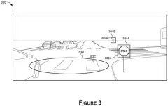
Roadside signs and cracks tagged in a car camera snapshot, drawing sheet 49 from US 2026/0366886 A1
Sheet 49 Roadside signs and cracks tagged in a car camera snapshot
Calculating exact distances to real-world objects from camera images, drawing sheet 50 from US 2026/0366886 A1
Sheet 50 Calculating exact distances to real-world objects from camera images
Vehicles uploading mapped road points to a central server, drawing sheet 51 from US 2026/0366886 A1
Sheet 51 Vehicles uploading mapped road points to a central server
Matching 3D points recorded from opposite driving directions, drawing sheet 52 from US 2026/0366886 A1
Sheet 52 Matching 3D points recorded from opposite driving directions
Steps a vehicle takes to log landmarks along its route, drawing sheet 53 from US 2026/0366886 A1
Sheet 53 Steps a vehicle takes to log landmarks along its route
Merging opposite-direction drives into a single lightweight map, drawing sheet 54 from US 2026/0366886 A1
Sheet 54 Merging opposite-direction drives into a single lightweight map
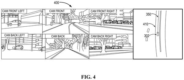
Two cars passing each other along a marked two-lane road, drawing sheet 55 from US 2026/0366886 A1
Sheet 55 Two cars passing each other along a marked two-lane road
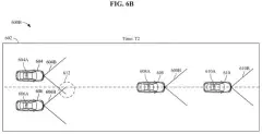
Aligning traffic paths using shared landmarks along the street, drawing sheet 56 from US 2026/0366886 A1
Sheet 56 Aligning traffic paths using shared landmarks along the street
Guiding a car along a road using mapped landmarks, drawing sheet 57 from US 2026/0366886 A1
Sheet 57 Guiding a car along a road using mapped landmarks
A car approaching a four-way intersection with traffic lights, drawing sheet 58 from US 2026/0366886 A1
Sheet 58 A car approaching a four-way intersection with traffic lights
Possible driving paths through an intersection, drawing sheet 59 from US 2026/0366886 A1
Sheet 59 Possible driving paths through an intersection
Matching landmark points seen by cars making the same turn, drawing sheet 60 from US 2026/0366886 A1
Sheet 60 Matching landmark points seen by cars making the same turn

Sheets 61 to 73 are in the full USPTO filing.

Patent filing page

Watchlists this filing belongs to

All watchlists →
Reader comments

No comments yet

Start the discussion

Real name or a handle, either is fine. Comments are read by a person before they appear, so allow a little time. Keep it about the filing.