
Sony Patents Technology That Reads Soil Wetness Across a Farm to Direct Irrigation
Sony is building a system that stitches together aerial moisture maps and in-ground sensors to tell farmers exactly where and when to water, down to a field-by-field level.
How Sony's moisture map turns sensor data into irrigation guidance
Farmers today mostly rely on scattered soil sensors or gut feeling to decide when to irrigate. A single sensor in the corner of a field can miss dry patches twenty yards away, and over-watering or under-watering a crop at the wrong time costs real money.
Sony's patent describes a two-step approach. First, a system builds a relative moisture map of a whole field, showing which areas are drier or wetter compared to each other. This kind of big-picture picture can come from satellite or drone imagery. Then, physical moisture sensors planted in the ground provide actual measured water levels, which the system uses to convert those relative comparisons into real, absolute numbers.
The end result is a map that tells you not just "this corner is drier than that one," but exactly how dry each spot is, giving irrigation systems the data they need to water only what needs watering.
a first creation unit configured to create a relative moisture amount map regarding a relative moisture amount in a field; an acquisition unit configured to acquire moisture amount data from a moisture amount sensor installed in the field …
Translation: The system uses sensors in the ground to build a map showing how wet different parts of the field are.
How relative maps get anchored to real ground-sensor readings
The patent describes a data processing apparatus with three coordinated parts:
- First creation unit: Builds a relative moisture amount map across a field. This captures the spatial pattern of moisture variation (which zones are wetter, which are drier) without necessarily knowing the exact water content at any point.
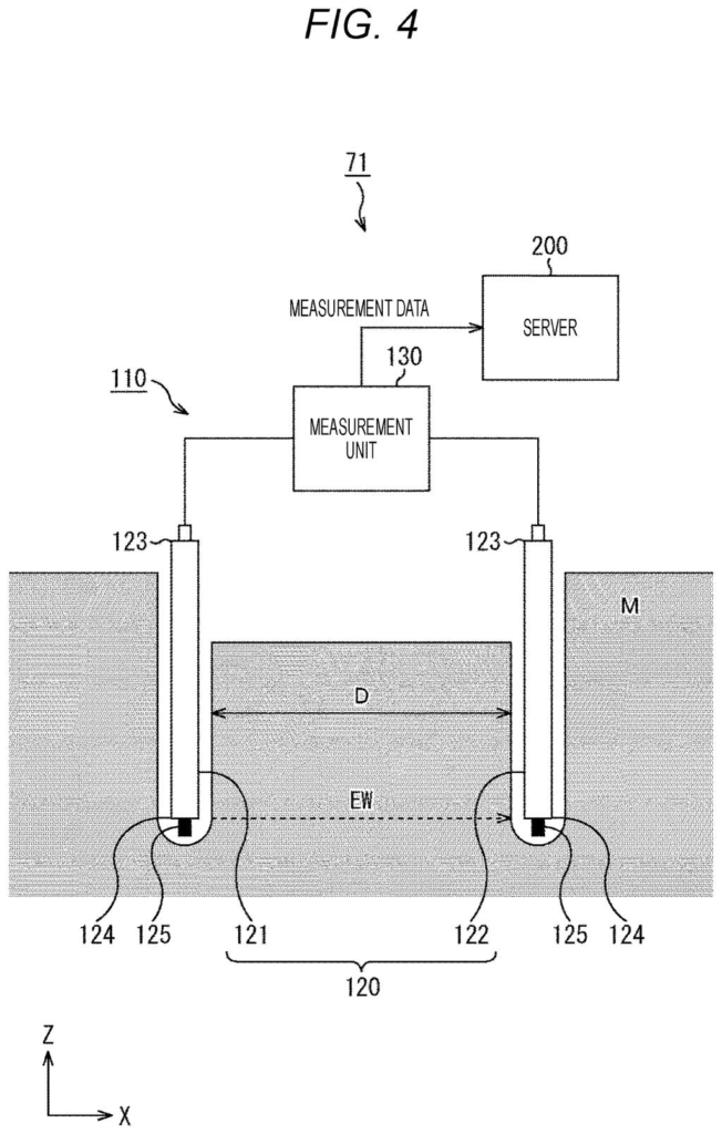
- Acquisition unit: Pulls readings from physical moisture sensors installed in the field. These sensors measure actual soil water content at specific locations.
- Second creation unit: Uses those real sensor readings as calibration anchors to convert the relative map into an absolute moisture amount map, meaning every point on the map now carries a real, measurable moisture value rather than just a comparison.
The key engineering insight is that aerial or remote-sensing data (satellites, drones, multispectral cameras) is good at capturing variation across space but often gives relative rather than absolute readings. Ground sensors are accurate but sparse. By combining both, the system gets the coverage of remote sensing with the accuracy of in-field measurement.
The resulting absolute moisture map is intended to feed directly into irrigation control systems, allowing water delivery to be targeted at the right spots rather than applied uniformly across an entire field.
The present technology can be applied to, for example, a data processing apparatus that acquires data for controlling irrigation of a field, appropriately detects a moisture amount in the field, and controls the irrigation.
Translation: This invention uses soil data to automatically manage how much water a farm receives.
What this means for precision agriculture technology
Precision irrigation is one of the bigger practical problems in modern agriculture. Water is expensive, over-irrigation causes runoff and nutrient loss, and under-irrigation cuts yields. A system that produces a reliable, field-wide moisture picture from a handful of sensors could reduce water use and improve crop outcomes without requiring a sensor every few feet.
Sony is not a company most people associate with farming, but the group has been expanding into sensing, imaging, and industrial data systems. This patent sits at the intersection of those areas, agriculture, remote sensing, and data fusion, where Sony's imaging expertise could translate into a real product edge. It joins the broader wave of new Big Tech patents targeting precision agriculture, an area where sensor data and spatial computing are finally maturing enough to deliver field-level accuracy.
Sony's 351st filing among patents we've tracked since May joins earlier work on parallel image compression and a faster-refresh display in our Sony coverage.
The system uses just a few sensors in the ground and fills in the rest of the picture using aerial data. That works well enough, but if the aerial data is wrong, say because of shadows, thick crops, or different soil types, those mistakes spread across the whole field.
This is a fair trade for large farms where putting sensors everywhere is not realistic. The risk moves onto the quality of that aerial data, and Sony, a company that builds cameras and sensors for a living, is well placed to solve it.
There are more where this came from
We read every patent application Big Tech publishes and send you the ones worth knowing. Plain English, free, every week.
The drawings
32 drawing sheets from US 2026/0243752 A1 · click any drawing to enlarge


Want this weekly breakdown for a company we don't cover? Patentlyze Pro →
Be the first to weigh in