
Amazon
Amazon · Automotive · Filed Jul 24, 2026 · USPTO published Nov 19, 2026 · This week's release
Amazon's Self-Driving Taxi Unit Patents Fix for Robotaxis Braking at Overpasses
A flat map can't tell an overpass from an intersection, so a car driving under a bridge may think the traffic above is about to cross its path. Zoox wants its maps to understand height.
- Publication number
- US 2026/0366887 A1(US20260366887A1)
- Applicant
- Zoox, Inc.
- Filed · Published
- Jul 24, 2026 · Nov 19, 2026
- Inventors
- Byungil JEONG, Gail Renee PINTO, Botong QU
- Status when we published
- Waiting for an examiner
- Document
- 20 claims
- US classification
- 701/450
- Parent application
- Continuation of 18/612,630 (filed Mar 21, 2024)(18612630)
What Zoox's overpass-aware maps actually do
Most digital maps are flat. Viewed from above, a road that passes over another road looks just like an intersection, even when no ramp connects the two.
That can confuse a self-driving car. If it treats the overpass and the road below as one big drivable area, it may see a car crossing above as one about to cut across its path, and brake or swerve for no reason. That is uncomfortable for riders and can puzzle other drivers.
Zoox's patent application teaches its maps about height. The system tags each stretch of road with a level, merges only the pieces that sit on the same level or truly connect, and keeps the overpass as a separate area. Your car can then drive under a bridge and ignore the traffic on top.
… determining the updated map comprising: combining the first road segment with the second road segment; and refraining from combining the first road segment with the third road segment; …
Translation: The system decides which overlapping roads to merge and which ones to keep separate.
How the map decides which roads to merge
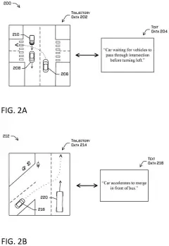
The system starts with a flat, top-down map built from road segments (short pieces of road). It turns each segment into a shape, then finds the places where shapes overlap on the page.
For each overlap, it decides whether to combine the shapes into one continuous drivable area. Two things drive that decision:
- Elevation information: each segment carries a level marker (for example 0 for ground level and 1 for a road passing above it) or an altitude, sampled along the road.
- Topological connection (whether the pieces are actually linked): one segment is the next or previous piece of the other, or both belong to the same junction.
Segments on the same level that connect get merged, which removes the boundary between them. Segments on different levels stay separate, so the overpass becomes its own drivable area. Ramps get a temporary "transition" level, and connections help place pieces correctly where elevation samples are sparse.
The finished map goes to the vehicle, which can query it to learn where it may drive and that the overhead road does not interact with its path. The filing also describes splitting the map into nested square tiles, packing it into compact data, and keeping a list of overlapping pairs that never interact, such as a road and the bridge above it.
An updated map is determined based on the combining or refraining from combining. The updated map is provided to a vehicle, causing the vehicle to traverse the first surface based on, or independently of, the second surface.
Translation: The corrected map helps the car drive correctly without confusing an overpass for its current road.
What this means for driving under bridges
The practical payoff is a smoother ride. A car that knows the bridge above is out of its way doesn't slow down or veer for traffic that will pass safely overhead. The same logic applies to elevated walkways, where the filing says the car should keep going even with pedestrians on top.
It also shows how much work goes into the map itself, well before the car's sensors get involved. Sensors see the overpass traffic fine. The map decides whether that traffic matters, so a mapping mistake can turn into a driving mistake. Fixing it in the map data also makes the data faster for the car to look up while it drives.
That makes this Amazon's 38th filing we've tracked since May in our self-driving sensing race watchlist, building on their work around sensors that vote on road safety and parking spots guiding robotaxis.
Source: US 2026/0366887 A1 at the USPTO (PDF). Full patent text and figures are in the official publication.
Get our take in your Top Stories
Liked this breakdown? Add Patentlyze as a preferred source on Google, and our plain-English take shows up more often in your Top Stories the next time Amazon patent news breaks.
Add Patentlyze on Google
One click.
There are more where this came from
We read every patent application Big Tech publishes and send you the ones worth knowing. Plain English, free, every week.
The drawings · 8 sheets
8 drawing sheets from US 2026/0366887 A1 · click any drawing to enlarge


More from Amazon
All 114 Amazon patents →
More in Automotive
All 377 Automotive patents →
Nvidia
Nvidia Files Patent for Using Maps to Find Rare Road Signs in Driving Footage
Mobileye (Intel)
Intel's Self-Driving Division Files Patent to Fix Gaps Between Digital Map Sections
Nvidia
Nvidia Files Patent to Help Self-Driving Cars Keep Track of the Same Pedestrian or Car
Nvidia
No comments yet