
Hilti
Hilti · Gear · Filed Jun 27, 2025 · USPTO published Nov 19, 2026 · This week's release
Hilti Files Patent for a Laser Surveyor That Works Out Where It's Standing
Setting up a surveying laser usually means telling it where it is by aiming at reflective targets. Hilti's patent application has the instrument figure that out itself by measuring the walls around it and checking them against the building's outline.
- Publication number
- US 2026/0366871 A1(US20260366871A1)
- Applicant
- Hilti Aktiengesellschaft
- Filed · Published
- Jun 27, 2025 · Nov 19, 2026
- Inventors
- Fernando REYES-AVILES, Thomas GLOOR, Clemens ARTH
- Status when we published
- Waiting for an examiner
- Document
- 13 claims
- US classification
- 356/4.01
- Parent application
- National Stage Entry of PCT/EP2023/087442 (filed Dec 21, 2023)(PCTEP2023087442)
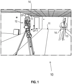
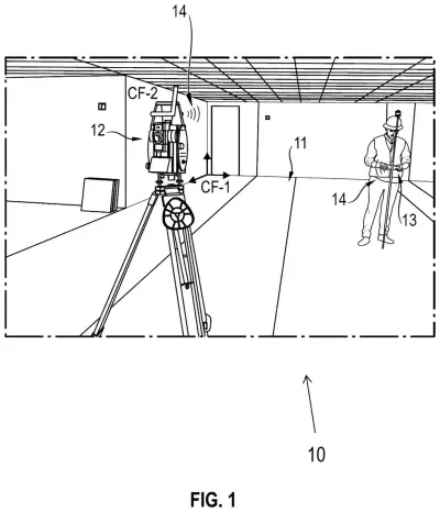
What Hilti's self-locating laser actually does
You've just set a laser surveying instrument down in the middle of a half-built floor. It can measure distances with great precision, but it has no idea where in the building it's standing. One common workflow fixes that by placing reflective foils or prisms at known spots and aiming the laser at each one by hand.
Hilti's patent application skips the stickers. The instrument spins through a full circle, measuring the distance to the walls around it, then compares those readings with the building's outline, such as a floor plan. That gives it a first guess at its location, and it then re-measures its most trustworthy spots more carefully.
From there it keeps testing new guesses, using just three readings at a time, and holds on to whichever guess fits the walls best. It stops when a preset rule says the answer is good enough.
selecting three measuring points from the second measuring points; for the selected three measuring points, an interim pose value is determined, the interim pose value is defined as a new pose for the laser instrument …
Translation: The device picks three points to calculate its exact location and orientation.
How the laser tests guesses against the floor plan
The invention is aimed at a robotic total station, a motorized surveying instrument that fires a laser to measure distance and tracks its own angles. Before it can do any work, it has to know its pose (its position and facing direction) inside the job site's coordinate system (the map grid of the building). Because the instrument already knows which way is down, the filing reduces the problem to three unknowns: two for position on the floor plan and one for rotation.
The method starts from a first pose estimate, built from a 360 degree scan and a polyline (a connected chain of straight line segments) that outlines the walls. The operator can draw it, or it can come from a floor plan. The laser then re-measures a chosen set of readings that pass quality checks, such as how far a reading sits from the wall line it should hit and how close it is to a wall corner. In the filing's example, 17 of 360 points are picked, possibly measured in a slower, more precise mode.
Then a repeating loop begins, in the style of RANSAC (trying small samples and keeping the best fit):
- Pick three readings and write an equation for the pose. It can have zero, one or two answers.
- Compare each result with the best one stored so far, using measures like how many readings fit, how they spread along the walls, or estimated accuracy.
- Keep the better one, then check a stop rule, such as a minimum number of rounds, to decide whether to loop again.
… a second polyline of the worksite environment composed of second straight line sections is determined by fitting the second measuring points …
Translation: It maps the room by connecting the measured points into straight lines.
What this means for Hilti's job site crews
For crews, the practical promise is a simpler start to the day: set the instrument down, let it scan, and let it work out where it is without reflective foils or prisms. The stated aim is also a more accurate position, since the loop keeps the best-fitting answer rather than the first one it finds.
That matters because every later measurement or layout task depends on that starting position. Robotic total stations are used in construction to take precise measurements, so a quicker, more reliable setup would be felt on a busy site. The filing gives no accuracy figures or timings, so how much it helps remains to be seen.
Hilti's second filing we've tracked in power tools & outdoor since November follows a self-checking surveying laser.
Source: US 2026/0366871 A1 at the USPTO (PDF). Full patent text and figures are in the official publication.
Get our take in your Top Stories
Liked this breakdown? Add Patentlyze as a preferred source on Google, and our plain-English take shows up more often in your Top Stories the next time Hilti patent news breaks.
Add Patentlyze on Google
One click.
There are more where this came from
We read the new patents from Big Tech, carmakers and more and send you the ones worth knowing. Plain English, free, every week.
The drawings · 6 sheets
6 drawing sheets from US 2026/0366871 A1 · click any drawing to enlarge


More from Hilti
All 4 Hilti patents →
More in Gear
All 26 Gear patents →
Greenworks
Greenworks Patents a Riding Mower With Motors Built Into Each Wheel and a Battery Mounted Below the Seat
Milwaukee
Milwaukee Tool Files Patent for Pipe Cameras That Label Rust, Cracks and Clogs
Makita
Makita Files Patent for a Demolition Hammer With Handles That Absorb Vibration

Milwaukee
No comments yet