
Amazon
Amazon · Automotive · Filed Jul 16, 2026 · USPTO published Nov 19, 2026 · This week's release
Amazon Unit Zoox Files Patent for Maps That Draw Their Own Lane Lines
Every driverless car leans on a map, and someone has to turn messy sensor readings into clean lane lines. Zoox's new patent application automates that chore, then adds a safety check that compares the map to what the car sees live.
- Publication number
- US 2026/0366877 A1(US20260366877A1)
- Applicant
- Zoox, Inc.
- Filed · Published
- Jul 16, 2026 · Nov 19, 2026
- Inventors
- Samir Chugh, Christopher James Gibson, Byungil Jeong, Timothy Robert Stolzenfeld
- Status when we published
- Waiting for an examiner
- Document
- 20 claims
- US classification
- 701/446
- Parent application
- Continuation of 18/592,318 (filed Feb 29, 2024)(18592318)
What Zoox's lane-line mapping tool does
Ever tried to connect a trail of messy dots into one clean, smooth line? That is the chore behind the maps a driverless car relies on. Cars driving around collect readings of painted lane lines, but the raw readings are patchy and noisy.
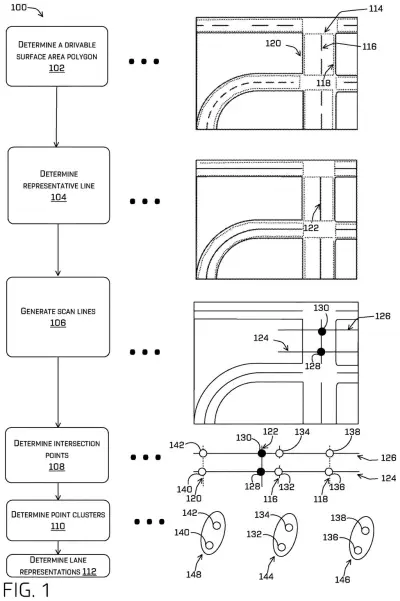
Zoox, the self-driving subsidiary of Amazon, filed a patent application for automating that cleanup. The system works out the middle of the road, then lays imaginary rulers across it at regular spacing and notes where each ruler crosses a lane line. Those crossing points get grouped, and each group becomes a smooth curve on the map.
A human map editor can still drag points around to fix errors, and the system recalculates the lines. The finished map then goes to the car's driving software, which uses it to plan where to steer.
… determining a line that intersects with the reference line at a first point and a lane boundary at a second point; receiving or determining an indication of a third point at which the line intersects with the lane boundary; determining, based at least in part on the reference line and the indication, a first representation of the lane boundary; …
Translation: The system maps where invisible lane borders sit relative to a known reference line on the road.
How Zoox measures lanes with sideways lines
The claims cover a system that takes sensor data about a stretch of road and finds a reference line running along it. It then draws a line across the road that meets the reference line at one point and a lane boundary at another. From that crossing point it builds a representation of the lane boundary, adds it to a map, and hands the map to a second system that plans a trajectory and controls the vehicle.
The description fills in the steps:
- Road surfaces that cars detected while driving are merged into one big outline (a polygon). Each piece is first expanded slightly so small gaps close.
- The reference line is the medial axis, a line through the middle of that outline, found with a Voronoi diagram (a way of splitting space by which point is nearest).
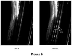
- Evenly spaced points on that line each get a perpendicular "scan line" that records where it crosses detected lane markings. Points near intersections are dropped when their curvature disagrees too much.
- The remaining points are clustered with an algorithm called DBSCAN, so each cluster is one lane line. A polynomial curve (a smooth, flexible curve) is fitted to the center line, and the other lines are described by their distance from it.
A cartographer can move control points on a visualization, and the system recomputes the lines. An automated check can also reject a low-confidence result. The filing also describes updating maps in real time on the vehicle and sharing them with nearby vehicles.
The system may determine a set of intersections of a set of lines that originate at the set of points and extend laterally from the representative line. The system may determine, based on the set of intersections, a representation of the lane boundary and associate the representation with the map data.
Translation: It projects intersecting lines outward to mathematically plot the missing boundaries onto the digital map.
Why cleaner lane lines matter for robotaxis
Lane lines in a map decide how well a driverless car stays centered, takes a curve, or avoids crossing a boundary. Drawing them by hand across a whole city is slow, and raw sensor data alone is too jagged to use. Automating the first draft and leaving a human to fix errors could make maps cheaper to build and keep current, which matters if you ride in a robotaxi in a city where roads and paint change.
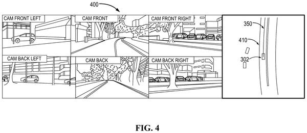
The filing also describes a backup role. The car compares what its own detectors see with the map's lane lines. If they disagree by too much, it can raise an alert, limit autonomous driving, or require manual intervention. For you as a passenger, that is a second opinion on whether the car's picture of the road is trustworthy.
That makes this Amazon's 39th filing we've tracked since May in our self-driving sensing race watchlist, following one on robotaxis braking at overpasses and one on sensors voting on road clearance.
Source: US 2026/0366877 A1 at the USPTO (PDF). Full patent text and figures are in the official publication.
Get our take in your Top Stories
Liked this breakdown? Add Patentlyze as a preferred source on Google, and our plain-English take shows up more often in your Top Stories the next time Amazon patent news breaks.
Add Patentlyze on Google
One click.
There are more where this came from
We read every patent application Big Tech publishes and send you the ones worth knowing. Plain English, free, every week.
The drawings · 5 sheets
5 drawing sheets from US 2026/0366877 A1 · click any drawing to enlarge


More from Amazon
All 114 Amazon patents →
More in Automotive
All 377 Automotive patents →
Qualcomm
Qualcomm Files Patent to Let Cars Pinpoint Each Other Using Painted Lane Lines
Google
Google Files Patent for Cars That Notice When Road Construction Moves the Lane Lines
Nvidia
Nvidia Files Patent to Pick the Right Lane Without Detailed Self-Driving Maps
Nvidia
No comments yet